Approximate Location Map
Large Map »
Latitude: 55.1659 / 55°9'57"N
Longitude: -1.6873 / 1°41'14"W
OS Eastings: 420015
OS Northings: 585778
OS Grid: NZ200857
Mapcode National: GBR J8NP.HZ
Mapcode Global: WHC2R.1FS2
Plus Code: 9C7W5887+93
Entry Name: Bollard by Rear Wall of Joiners Arms
Listing Date: 22 August 1986
Grade: II
Source: Historic England
Source ID: 1042726
English Heritage Legacy ID: 238727
ID on this website: 101042726
Location: Morpeth, Northumberland, NE61
County: Northumberland
Civil Parish: Morpeth
Built-Up Area: Morpeth
Traditional County: Northumberland
Lieutenancy Area (Ceremonial County): Northumberland
Church of England Parish: Morpeth
Church of England Diocese: Newcastle
Tagged with: Bollard
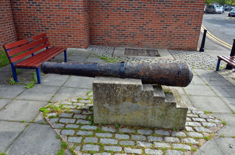
MORPETH HILLGATE
NZ 2085
25/239 Bollard by rear wall
of Joiner's Arms
II
Bollard. C17 cast iron. Re-used cannon barrel.
Listing NGR: NZ2001585779
External links are from the relevant listing authority and, where applicable, Wikidata. Wikidata IDs may be related buildings as well as this specific building. If you want to add or update a link, you will need to do so by editing the Wikidata entry.


Other nearby listed buildings
