Approximate Location Map
Large Map »
Latitude: 53.3227 / 53°19'21"N
Longitude: -0.9401 / 0°56'24"W
OS Eastings: 470697
OS Northings: 381162
OS Grid: SK706811
Mapcode National: GBR PZW0.8M
Mapcode Global: WHFG8.JRK4
Plus Code: 9C5X83F5+3X
Entry Name: 35, Grove Street
Listing Date: 5 November 1976
Grade: II
Source: Historic England
Source ID: 1045175
English Heritage Legacy ID: 240913
ID on this website: 101045175
Location: Retford, Bassetlaw, Nottinghamshire, DN22
County: Nottinghamshire
District: Bassetlaw
Electoral Ward/Division: East Retford East
Parish: Non Civil Parish
Built-Up Area: Retford
Traditional County: Nottinghamshire
Lieutenancy Area (Ceremonial County): Nottinghamshire
Church of England Parish: Retford Team
Church of England Diocese: Southwell and Nottingham
Tagged with: Building
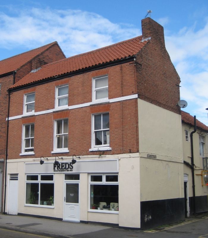
GROVE STREET
1.
5345
(North Side)
No 35
SK 7081 SE 1/112
II
2.
Late C18 or early C19. 3 storeys in red brick with pantile roof with end stacks.
3 windows, brick voussoirs, painted band at cills. Ground floor rendered, with
modern shop front.
Listing NGR: SK7069781162
External links are from the relevant listing authority and, where applicable, Wikidata. Wikidata IDs may be related buildings as well as this specific building. If you want to add or update a link, you will need to do so by editing the Wikidata entry.


Other nearby listed buildings
