Approximate Location Map
Large Map »
Latitude: 54.8479 / 54°50'52"N
Longitude: -2.055 / 2°3'18"W
OS Eastings: 396563
OS Northings: 550342
OS Grid: NY965503
Mapcode National: GBR GD2C.WY
Mapcode Global: WHB2Z.DDNW
Plus Code: 9C6VRWXV+4X
Entry Name: The Angel
Listing Date: 15 April 1969
Grade: II
Source: Historic England
Source ID: 1045384
English Heritage Legacy ID: 240403
ID on this website: 101045384
Location: Blanchland, Northumberland, DH8
County: Northumberland
Civil Parish: Blanchland
Traditional County: Northumberland
Lieutenancy Area (Ceremonial County): Northumberland
Church of England Parish: Blanchland with Hunstanworth
Church of England Diocese: Newcastle
Tagged with: Building
BLANCHLAND THE SQUARE Blanchland
NY 9650
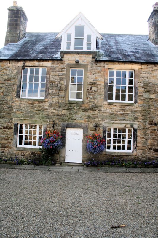
24/36 The Angel
(west side)
15.4.69
GV II
Former inn, now part of Lord Crewe Arms. Part of medieval monastic outer court
range, remodelled and extended to rear in mid C18; altered, with new roof, mid
C19, probably by S.S. Teulon. Rubble with cut and tooled dressings; slate roof.
Front elevation 2 storeys + attic, 3 bays. Central renewed door with 8-pane
sash above, flanking bays with margined sashes; all openings in raised stone
surrounds except for small 4-pane casement, on ground floor far right, in C17
or earlier chamfered surround. Central gabled dormer with tripartite window;
steeply-pitched roof with 2 flanking stacks on each return. Rear elevation shows
20-pane sash stair window with intersecting glazing bars in head; raised round-
arched surround with imposts and chamfered keystone. Rear roof slope has banded
diaper pattern in blue, purple and green slate.
Interior: Front section retains 1-metre-thick walls of medieval range; rear
section has stair with stick balusters, grip handrail and moulded newels.
Listing NGR: NY9656350341
External links are from the relevant listing authority and, where applicable, Wikidata. Wikidata IDs may be related buildings as well as this specific building. If you want to add or update a link, you will need to do so by editing the Wikidata entry.


Other nearby listed buildings
