Approximate Location Map
Large Map »
Latitude: 52.4123 / 52°24'44"N
Longitude: -1.7365 / 1°44'11"W
OS Eastings: 418020
OS Northings: 279398
OS Grid: SP180793
Mapcode National: GBR 4J1.RT1
Mapcode Global: VH9ZC.VMBL
Plus Code: 9C4WC767+WC
Entry Name: Henwood Mill
Listing Date: 5 December 1949
Grade: II
Source: Historic England
Source ID: 1045849
English Heritage Legacy ID: 218072
ID on this website: 101045849
Location: Solihull, West Midlands, B91
County: Solihull
Civil Parish: Barston
Traditional County: Warwickshire
Lieutenancy Area (Ceremonial County): West Midlands
Church of England Parish: Solihull
Church of England Diocese: Birmingham
Tagged with: Mill
1.
BARSTON
5108
SP 17 NE
3/76
5.12.49
HENWOOD LANE
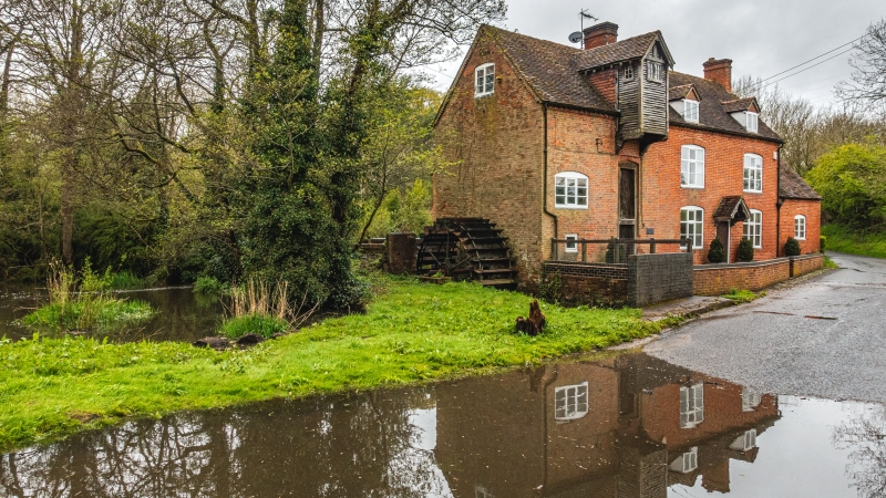
Henwood Mill
.
II
2.
C18 altered C19. Red brick, tiled roof. 2 storeys and attics, 2 gabled dormers.
2 C19 casement windows. Gabled doorhood. Weather boarded gable on left over mill
doors. Single storey whitewashed garage wing on right.
Listing NGR: SP1802079398
External links are from the relevant listing authority and, where applicable, Wikidata. Wikidata IDs may be related buildings as well as this specific building. If you want to add or update a link, you will need to do so by editing the Wikidata entry.


Other nearby listed buildings
