Approximate Location Map
Large Map »
Latitude: 53.2005 / 53°12'1"N
Longitude: -0.8109 / 0°48'39"W
OS Eastings: 479531
OS Northings: 367705
OS Grid: SK795677
Mapcode National: GBR CK2.CT1
Mapcode Global: WHFGX.JT39
Plus Code: 9C5X652Q+5M
Entry Name: The Pinfold
Listing Date: 19 September 1985
Grade: II
Source: Historic England
Source ID: 1045980
English Heritage Legacy ID: 242747
ID on this website: 101045980
Location: Grassthorpe, Newark and Sherwood, Nottinghamshire, NG23
County: Nottinghamshire
District: Newark and Sherwood
Civil Parish: Grassthorpe
Traditional County: Nottinghamshire
Lieutenancy Area (Ceremonial County): Nottinghamshire
Tagged with: Building
SK 76 NE
1/44
GRASSTHORPE
COPPER HILL
(north side)
The Pinfold
II
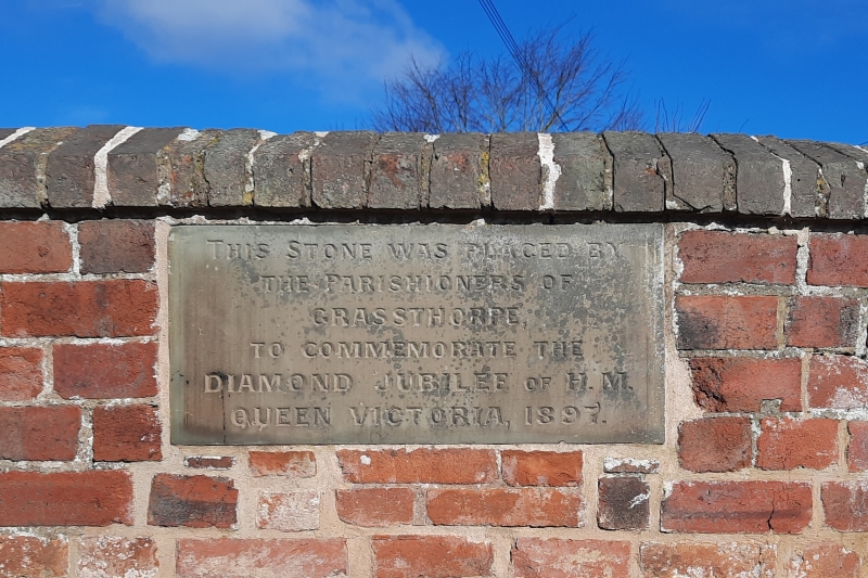
Village pinfold. C19, raised 1897. Brick with triangular brick
coping. Square plan. Rounded corner to south east. 2 square
brick piers with dressed stone caps. Inscribed stone relating to
Diamond Jubilee, 1897.
Listing NGR: SK7953167705
External links are from the relevant listing authority and, where applicable, Wikidata. Wikidata IDs may be related buildings as well as this specific building. If you want to add or update a link, you will need to do so by editing the Wikidata entry.


Other nearby listed buildings
