Approximate Location Map
Large Map »
Latitude: 51.73 / 51°43'47"N
Longitude: -1.2404 / 1°14'25"W
OS Eastings: 452554
OS Northings: 203748
OS Grid: SP525037
Mapcode National: GBR 8ZB.K62
Mapcode Global: VHCXV.GS25
Plus Code: 9C3WPQH5+XR
Entry Name: Roving Bridge Twenty Yards Upstream from Iffley Lock
Listing Date: 28 June 1972
Grade: II
Source: Historic England
Source ID: 1047191
English Heritage Legacy ID: 245664
ID on this website: 101047191
Location: Iffley, Oxford, Oxfordshire, OX4
County: Oxfordshire
District: Oxford
Electoral Ward/Division: Hinksey Park
Parish: Non Civil Parish
Traditional County: Oxfordshire
Lieutenancy Area (Ceremonial County): Oxfordshire
Church of England Parish: Iffley
Church of England Diocese: Oxford
Tagged with: Building Bridge Roving bridge
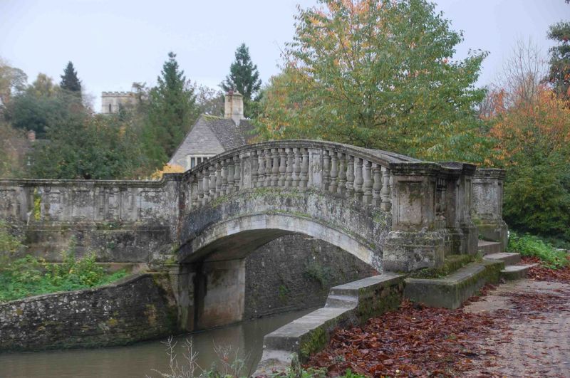
MILL LANE
1.
1485
(West Side)
Roving Bridge
twenty yards upstream
from Iffley Lock.
SP 5203 NE 14/770
II
2.
Early Cl9. Ashlar. Single elliptical arch with balustrades on either side.
Steps and landing with bronze bull's head. Starting ring inscribed (OUBC
1924).
Listing NGR: SP5255403748
External links are from the relevant listing authority and, where applicable, Wikidata. Wikidata IDs may be related buildings as well as this specific building. If you want to add or update a link, you will need to do so by editing the Wikidata entry.


Other nearby listed buildings
