Approximate Location Map
Large Map »
Latitude: 51.7524 / 51°45'8"N
Longitude: -1.2738 / 1°16'25"W
OS Eastings: 450229
OS Northings: 206213
OS Grid: SP502062
Mapcode National: GBR 7XS.2SM
Mapcode Global: VHCXT.V6ZZ
Plus Code: 9C3WQP2G+WF
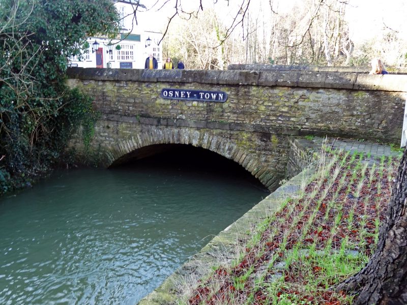
Entry Name: Bridge at North End of Street Forming the Junction with Botley Road
Listing Date: 28 June 1972
Grade: II
Source: Historic England
Source ID: 1047341
English Heritage Legacy ID: 245346
ID on this website: 101047341
Location: Osney, Oxford, Oxfordshire, OX2
County: Oxfordshire
District: Oxford
Electoral Ward/Division: Jericho and Osney
Parish: Non Civil Parish
Built-Up Area: Oxford
Traditional County: Oxfordshire
Lieutenancy Area (Ceremonial County): Oxfordshire
Church of England Parish: Oxford St Frideswide with Binsey
Church of England Diocese: Oxford
Tagged with: Bridge
1.
1485
SP 50 NW
24/690
BRIDGE STREET
Bridge at North end of Street forming the junction with Botley Road
II
2.
C19. Single span coursed rubble bridge with ashlar parapet walls.
Listing NGR: SP5022906213
External links are from the relevant listing authority and, where applicable, Wikidata. Wikidata IDs may be related buildings as well as this specific building. If you want to add or update a link, you will need to do so by editing the Wikidata entry.


Other nearby listed buildings
