Approximate Location Map
Large Map »
Latitude: 51.6461 / 51°38'46"N
Longitude: -1.1674 / 1°10'2"W
OS Eastings: 457708
OS Northings: 194474
OS Grid: SU577944
Mapcode National: GBR 90D.RPS
Mapcode Global: VHCY8.QW7G
Plus Code: 9C3WJRWM+C3
Entry Name: The Doctor's House
Listing Date: 18 July 1963
Last Amended: 14 May 1986
Grade: II
Source: Historic England
Source ID: 1047844
English Heritage Legacy ID: 248126
ID on this website: 101047844
Location: Dorchester, South Oxfordshire, OX10
County: Oxfordshire
District: South Oxfordshire
Civil Parish: Dorchester
Built-Up Area: Dorchester
Traditional County: Oxfordshire
Lieutenancy Area (Ceremonial County): Oxfordshire
Church of England Parish: Dorchester
Church of England Diocese: Oxford
Tagged with: House
DORCHESTER HIGH STREET
SU5794 (West side)
5/96 No.71 (The Doctor's House)
18/07/63 (Formerly listed as The
Doctor's House)
GV II
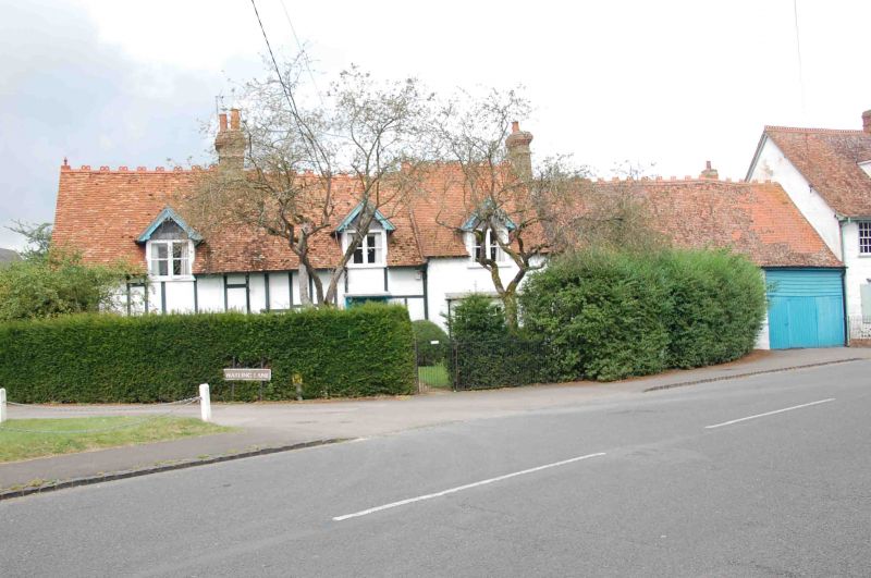
House and outbuilding. Late C16/early C17, extended and remodelled late C18 and
mid/late C19; outbuilding early C18. Timber framing with colourwashed brick
infill; some weatherboarding and brick; old plain-tile roof with brick stacks.
L-plan. One storey plus attics. 3-window C19 front, with applied timbering to
left and centre bays, has a central 4-panel door with a canopy on shaped
brackets, casements of one and 2 lights, to left, and a C20 canted bay window to
right; first floor has 3 gabled dormers. Roof has ornamental ridge tiles and
apex finials, and has stacks to left of centre and to right. Left gable wall has
a C19 canted bay window. Earlier rear wing has a 3-unit plan with continuous
outshut and is timber framed with some herringbone brick infill. It is partly
concealed by a small C18 wing at the junction with the front range. To right of
the front is a 3-bay timber-framed outbuilding range, probably originally a
barn. The front wall is now brick with the entry to right, but the rear remains
weatherboarded. Interior: front range has some chamfered beams and probably
incorporates C17/C18 work; outbuilding range has a clasped-purlin roof with
queen-strut trusses.
Listing NGR: SU5770894474
External links are from the relevant listing authority and, where applicable, Wikidata. Wikidata IDs may be related buildings as well as this specific building. If you want to add or update a link, you will need to do so by editing the Wikidata entry.


Other nearby listed buildings
