Approximate Location Map
Large Map »
Latitude: 51.643 / 51°38'34"N
Longitude: -1.1648 / 1°9'53"W
OS Eastings: 457888
OS Northings: 194132
OS Grid: SU578941
Mapcode National: GBR 90F.SDK
Mapcode Global: VHCY8.RYKV
Plus Code: 9C3WJRVP+63
Entry Name: The Toll House and Attached Churchyard Wall
Listing Date: 18 July 1963
Last Amended: 14 May 1986
Grade: II
Source: Historic England
Source ID: 1047862
English Heritage Legacy ID: 248070
ID on this website: 101047862
Location: Dorchester, South Oxfordshire, OX10
County: Oxfordshire
District: South Oxfordshire
Civil Parish: Dorchester
Built-Up Area: Dorchester
Traditional County: Oxfordshire
Lieutenancy Area (Ceremonial County): Oxfordshire
Church of England Parish: Dorchester
Church of England Diocese: Oxford
Tagged with: Building
DORCHESTER HIGH STREET
SU5794 (East side)
5/41 The Toll House and attached
18/07/63 churchyard wall
(Formerly listed as Turnpike
Cottage)
GV II
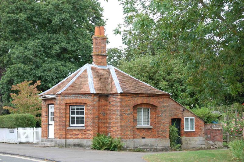
Toll house, now office. Early C19. Brick with rubbed-brick arches, on a
limestone ashlar plinth; old plain-tile and Welsh-slate roofs. Plan has a half
octagon breaking forward from a rectangular section, plus a rear outshut. One
storey. Front has a central doorway with a stone pedimented canopy on carved
brackets and a sash door; 12-pane sashes in canted sides are set within recesses
with cambered arches. Leaded casements, in end walls of rectangular section, are
set within segmental-arched recesses. Hipped roof has a central octagonal brick
stack. Slated outshut has further leaded casements and plank door. Inscriptions
on plinth record several floods, the earliest 1823. Interior not inspected. C17,
or earlier, churchyard wall runs approx. 35 metres. to left and 1 metre to
right. It is of large limestone ashlar blocks with later brick coping.
Listing NGR: SU5788894132
External links are from the relevant listing authority and, where applicable, Wikidata. Wikidata IDs may be related buildings as well as this specific building. If you want to add or update a link, you will need to do so by editing the Wikidata entry.


Other nearby listed buildings
