Approximate Location Map
Large Map »
Latitude: 51.5989 / 51°35'56"N
Longitude: -1.6546 / 1°39'16"W
OS Eastings: 424020
OS Northings: 188956
OS Grid: SU240889
Mapcode National: GBR 5WC.NJ1
Mapcode Global: VHC0Y.82ML
Plus Code: 9C3WH8XW+H5
Entry Name: Village School
Listing Date: 10 November 1952
Last Amended: 31 October 1983
Grade: II
Source: Historic England
Source ID: 1048795
English Heritage Legacy ID: 250594
ID on this website: 101048795
Location: Shrivenham, Vale of White Horse, Oxfordshire, SN6
County: Oxfordshire
District: Vale of White Horse
Civil Parish: Shrivenham
Built-Up Area: Shrivenham
Traditional County: Berkshire
Lieutenancy Area (Ceremonial County): Oxfordshire
Church of England Parish: Shrivenham with Watchfield and Bourton
Church of England Diocese: Oxford
Tagged with: Building
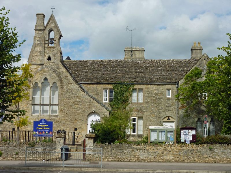
1. SHRIVENHAM HIGH STREET
(north side)
SU 2488 8/45 10.11.52 Village School
(formerly listed as
II GV the Old School House)
2.
1863 in Gothic style enlarged in 1899 of rubble stone and stone dressings with a
gabled stone tiled roof and 3 stone stacks. The roadside front reveals the plan of
School Hall at right angles to the road, gable ended with a bellcote and chimney stack
cleverly combined and adjoining to the E, the Schoolmaster's house. A further
1 storey gabled range to the W is the 1899 addition. A stepped and pointed 3 cusped
light window lights the hall and there is a 3 cusped light window to the ground floor
gable end of the Schoolmaster's house. The range between is of 2 storeys and has 2
and 3 light mullions. The schoolroom door is ledged with wrought iron hinges under a
depressed pointed arch. A similar door with less elaborate ironwork gives access to
the master's house. The bellcote has a trefoiled opening below it and a triangular gable-above faith a finial.
A catslide roof porjects over 1 storey ranges to the rear.
Listing NGR: SU2402088956
External links are from the relevant listing authority and, where applicable, Wikidata. Wikidata IDs may be related buildings as well as this specific building. If you want to add or update a link, you will need to do so by editing the Wikidata entry.


Other nearby listed buildings
