Approximate Location Map
Large Map »
Latitude: 51.5624 / 51°33'44"N
Longitude: -1.1469 / 1°8'48"W
OS Eastings: 459231
OS Northings: 185183
OS Grid: SU592851
Mapcode National: GBR 91D.YNK
Mapcode Global: VHCYP.2ZJM
Plus Code: 9C3WHV63+X6
Entry Name: The Gables
Listing Date: 20 November 1992
Grade: II
Source: Historic England
Source ID: 1052183
English Heritage Legacy ID: 361499
ID on this website: 101052183
Location: South Oxfordshire, OX10
County: Oxfordshire
District: South Oxfordshire
Civil Parish: Cholsey
Traditional County: Berkshire
Lieutenancy Area (Ceremonial County): Oxfordshire
Church of England Parish: Cholsey
Church of England Diocese: Oxford
Tagged with: Building
The following building shall be added:-
CHOLSEY
READING ROAD
SUSBNE
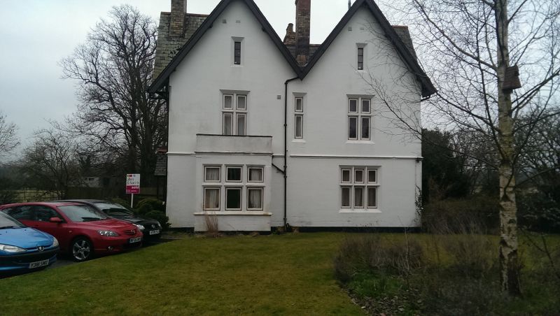
2/10001 The Gables
GV II
Former station hotel/tavern. c1841, probably by I.K. Brunel for the
Great Western Railway. Painted red brick with stone dressings. Slated
roofs with 2 steeply pitched gables, having projecting eaves and
bargeboards, to each facade; tall brick chimney stacks, 2 rising from
ground floor through gables. Square plan with 2 bays to each facade.
2 storeys and attic. Main facade symmetrical with Tudor-arched
entrance flanked by transom and mullion windows to ground and 1st
floor; narrow vertically set window above entrance. Similar narrow
windows to attic. Other facades in similar style with half glazed
doors having intersecting tracery to glazing bars in Tudor arched
doorways; platform elevation has remains of a canopy flanked by 2
canted bay windows. Interior retains staircase with turned newels and
original panelled doors. This building is an early example of a
station hotel; the platform, with only a simple shelter, was reached
at the end of a sloping drive. It was originally named Wallingford
Road, being-renamed Moulsford station in 1866 after the opening of the
Wallingford Branch Line.
Listing NGR: SU5923185183
External links are from the relevant listing authority and, where applicable, Wikidata. Wikidata IDs may be related buildings as well as this specific building. If you want to add or update a link, you will need to do so by editing the Wikidata entry.


Other nearby listed buildings
