Approximate Location Map
Large Map »
Latitude: 51.77 / 51°46'12"N
Longitude: -1.5694 / 1°34'9"W
OS Eastings: 429812
OS Northings: 208016
OS Grid: SP298080
Mapcode National: GBR 5TC.S3R
Mapcode Global: VHC00.RR6Y
Plus Code: 9C3WQCCJ+27
Entry Name: Rookery Farmhouse and Attached Wall
Listing Date: 17 October 1988
Grade: II
Source: Historic England
Source ID: 1052443
English Heritage Legacy ID: 252105
ID on this website: 101052443
Location: Brize Norton, West Oxfordshire, OX18
County: Oxfordshire
District: West Oxfordshire
Civil Parish: Brize Norton
Traditional County: Oxfordshire
Lieutenancy Area (Ceremonial County): Oxfordshire
Church of England Parish: Brize Norton
Church of England Diocese: Oxford
Tagged with: Farmhouse
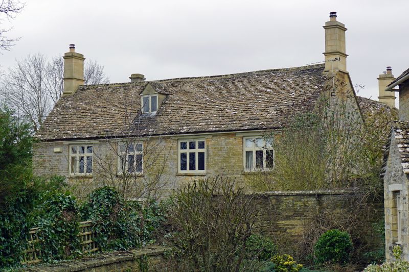
BRIZE NORTON BURFORD ROAD
SP20NE (South side)
5/34 Rookery Farmhouse and attached
wall
GV II
House. C18 with late C16/early C17 origins; refronted and rear block built in
early C19. Coursed limestone rubble, with squared and coursed stone to front;
gabled stone slate roof; stone ashlar moulded end stacks. L-plan with rear right
wing. storeys and attic; 4-window range. Chamfered timber lintels over late
C19 and C20 three-light casements. Rear wing of similar materials with old
timber lintels and stone-coped gable. Early C19 rear range, to left: of similar
materials with C20 door set in stone porch. Interior: chamfered beams, including
late C16/early C17 chamfered beam with roll stop in room to left. Early C19
dog-leg with winders staircase, with stick balusters and fret-cut brackets.
Collar-truss roof with butt purlins. Subsidiary features: tall stone-coped
limestone rubble wall, extends approximately 12 metres from front right to join
The Cottage (q.v.).
Listing NGR: SP2981208016
External links are from the relevant listing authority and, where applicable, Wikidata. Wikidata IDs may be related buildings as well as this specific building. If you want to add or update a link, you will need to do so by editing the Wikidata entry.


Other nearby listed buildings
