Approximate Location Map
Large Map »
Latitude: 51.6922 / 51°41'32"N
Longitude: -1.6425 / 1°38'32"W
OS Eastings: 424807
OS Northings: 199336
OS Grid: SU248993
Mapcode National: GBR 5V6.ZGN
Mapcode Global: VHC0C.HQ1L
Plus Code: 9C3WM9R5+V2
Entry Name: Home Lea
Listing Date: 30 March 1989
Grade: II
Source: Historic England
Source ID: 1053410
English Heritage Legacy ID: 253815
ID on this website: 101053410
Location: Kelmscott, West Oxfordshire, GL7
County: Oxfordshire
District: West Oxfordshire
Civil Parish: Kelmscott
Traditional County: Oxfordshire
Lieutenancy Area (Ceremonial County): Oxfordshire
Church of England Parish: Broadwell with Kelmscott
Church of England Diocese: Oxford
Tagged with: Building
KELMSCOTT
SU2499-2599
Home Lea
- II
10/63
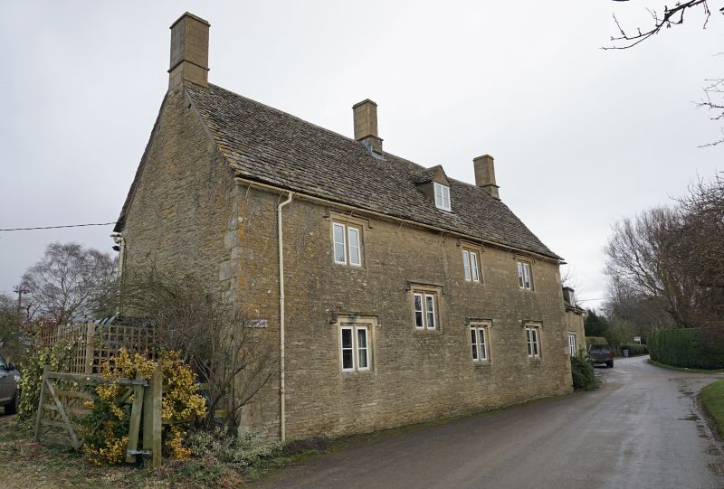
Farmhouse, now house. Late C17 extended 1767 (datestone) with later additions
and alterations. Uncoursed limestone rubble; stone slate roofs. 3-unit
baffle-entry plan with lower range dated 1767 set back to left. 2 storeys and
attic. Mullioned windows with dripstones throughout, 4 directly below eaves and
3 to ground floor, one to left and 2 to right of entrance, all of 2 lights
except for 3-light windows directly to either side of roughly central entrance,
which has small C20 casement immediately to left. Gabled dormers in middle of
roof slope to left and right. Integral end stacks, shaft of right totally
rebuilt in C20 and left rebuilt above dripstone. Ridge stack immediately to
right of centre has shaft rebuilt above dripstone. Entrance through C20
four-panel door under gabled bracketed hood. C18 range to left has integral end
stack rebuilt in C20 with datestone "TM 1767" below shaft. Rectangular bread
oven projection to base. Rear (road side) also has 2-light mullion windows with
dripstones. 3 directly below eaves and 3 to ground floor; another lighting
staircase between left and centre bays. Roughly central gabled dormer in roof
slope. C18 addition has two C20 casements with concrete lintels and two C20
eaves dormers. Interior. Chamfered spine beans to ground- and first-floor rooms
of main range with winder staircases to sides of end stacks leading from first
floor to attic (corresponding staircases from ground to first floor now
removed). Attic has double-purlin collar truss roof in 5 bays. C18 addition has
chamfered spine bean and joists to ground floor with position of winder
staircase visible to right of inglenook fireplace, which has chamfered wood
lintel. Similar roof to that of main range in 2 bays.
[2358]
Listing NGR: SU2480799336
External links are from the relevant listing authority and, where applicable, Wikidata. Wikidata IDs may be related buildings as well as this specific building. If you want to add or update a link, you will need to do so by editing the Wikidata entry.


Other nearby listed buildings
