Approximate Location Map
Large Map »
Latitude: 52.535 / 52°32'6"N
Longitude: -2.4216 / 2°25'17"W
OS Eastings: 371499
OS Northings: 293102
OS Grid: SO714931
Mapcode National: GBR BZ.F6KJ
Mapcode Global: VH83H.ZK50
Plus Code: 9C4VGHPH+29
Entry Name: 55, St Mary's Street
Listing Date: 9 March 1970
Grade: II
Source: Historic England
Source ID: 1053925
English Heritage Legacy ID: 254545
ID on this website: 101053925
Location: Bridgnorth, Shropshire, WV16
County: Shropshire
Civil Parish: Bridgnorth
Built-Up Area: Bridgnorth
Traditional County: Shropshire
Lieutenancy Area (Ceremonial County): Shropshire
Church of England Parish: Bridgnorth
Church of England Diocese: Hereford
Tagged with: Building
This list entry was subject to a Minor Amendment on 13/01/2020
SO 79 SW
2/214
BRIDGNORTH
ST MARY'S STREET (south side)
No 55
9.3.70
GV
II
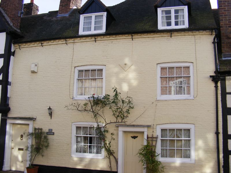
Probably C18. Colourwashed brick; two storeys; two sash windows; two simple doors; two gabled dormers; old tiles.
Nos 50 to 64 (consec), Nos 65 and 68, No 68A, and Nos 69 to 73 (consec) form a group
Listing NGR: SO7149993102
External links are from the relevant listing authority and, where applicable, Wikidata. Wikidata IDs may be related buildings as well as this specific building. If you want to add or update a link, you will need to do so by editing the Wikidata entry.


Other nearby listed buildings
