Approximate Location Map
Large Map »
Latitude: 53.3277 / 53°19'39"N
Longitude: -1.9835 / 1°59'0"W
OS Eastings: 401193
OS Northings: 381197
OS Grid: SK011811
Mapcode National: GBR GYLY.CT
Mapcode Global: WHBBC.HMP8
Plus Code: 9C5W82H8+3H
Entry Name: Methodist Church and Sunday School
Listing Date: 19 September 1977
Grade: II
Source: Historic England
Source ID: 1054734
English Heritage Legacy ID: 81874
ID on this website: 101054734
Location: Whaley Bridge, High Peak, Derbyshire, SK23
County: Derbyshire
District: High Peak
Civil Parish: Whaley Bridge
Built-Up Area: Whaley Bridge
Traditional County: Derbyshire
Lieutenancy Area (Ceremonial County): Derbyshire
Church of England Parish: Whaley Bridge, Taxal St James
Church of England Diocese: Chester
Tagged with: Church building
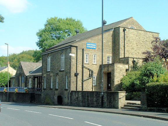
WHALEY BRIDGE BUXTON ROAD
1.
5172
(East Side)
Methodist Church and
Sunday School
SK 0181 1/3
II
2.
3 units, the centre, dated 1821, being the earliest, and the others being the chapel
and school room. The centre unit has 3 round-headed windows to the upper floor,
cambered arches to the lower floor, with keystones. Arched doorway with keystone
and double doors, rectangular fanlight of 4 arched lights. The right-hand wing
is the school room, of later C19 date, of 3 storeys with 2 round-headed windows.
The left-hand building is the chapel of 1867. The gabled centre, with rusticated
quoins, breaks forward slightly. Round-headed window with Gothic glazing bars,
2 lights, in reveal, band at cill above doorway with rusticated surround and round-
headed entry. The sides have 1 round-headed window each above 1 with segmental
head. The school room to the right and the chapel are included for group value.
Listing NGR: SK0119381197
External links are from the relevant listing authority and, where applicable, Wikidata. Wikidata IDs may be related buildings as well as this specific building. If you want to add or update a link, you will need to do so by editing the Wikidata entry.


Other nearby listed buildings
