Approximate Location Map
Large Map »
Latitude: 52.9068 / 52°54'24"N
Longitude: -2.8923 / 2°53'32"W
OS Eastings: 340085
OS Northings: 334742
OS Grid: SJ400347
Mapcode National: GBR 79.NZY6
Mapcode Global: WH89S.J6YF
Plus Code: 9C4VW445+P3
Entry Name: 7-9, Birch Road
Listing Date: 5 April 1982
Grade: II
Source: Historic England
Source ID: 1055540
English Heritage Legacy ID: 259798
ID on this website: 101055540
Location: Ellesmere, Shropshire, SY12
County: Shropshire
Civil Parish: Ellesmere Urban
Built-Up Area: Ellesmere
Traditional County: Shropshire
Lieutenancy Area (Ceremonial County): Shropshire
Church of England Parish: Ellesmere St Mary
Church of England Diocese: Lichfield
Tagged with: Building
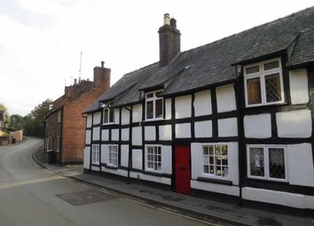
BIRCH ROAD
1.
5358
Nos 7 to 9 (consec)
SJ 4034 8/4
II GV
2.
Early C17. A range of cottages; timber frame and painted brick with slate roof;
one storey and attic; 4 dormered casement windows (some with early leaded lights)
breaking above eaves. Alteration work in hand at time of inspection (1980).
Listing NGR: SJ4008534741
External links are from the relevant listing authority and, where applicable, Wikidata. Wikidata IDs may be related buildings as well as this specific building. If you want to add or update a link, you will need to do so by editing the Wikidata entry.


Other nearby listed buildings
