Approximate Location Map
Large Map »
Latitude: 52.3563 / 52°21'22"N
Longitude: -0.9608 / 0°57'38"W
OS Eastings: 470872
OS Northings: 273648
OS Grid: SP708736
Mapcode National: GBR BTT.9WQ
Mapcode Global: VHDRK.91FG
Plus Code: 9C4X924Q+GM
Entry Name: Lodge, Gates and Gatepiers to Cottesbrooke Hall (West)
Listing Date: 2 November 1954
Last Amended: 8 November 1984
Grade: II
Source: Historic England
Source ID: 1055735
English Heritage Legacy ID: 360118
ID on this website: 101055735
Location: Cottesbrooke, West Northamptonshire, NN6
County: West Northamptonshire
Civil Parish: Cottesbrooke
Traditional County: Northamptonshire
Lieutenancy Area (Ceremonial County): Northamptonshire
Church of England Parish: Cottesbrooke All Saints
Church of England Diocese: Peterborough
Tagged with: Building
SP7073 COTTESBROOKE COTTESBROOKE
14/129 Lodge, gates and gatepiers to
02/11/54 Cottesbrooke Hall (west)
(north side)
(Formerly listed as
Cottesbrooke Hall Lodges)
GV II
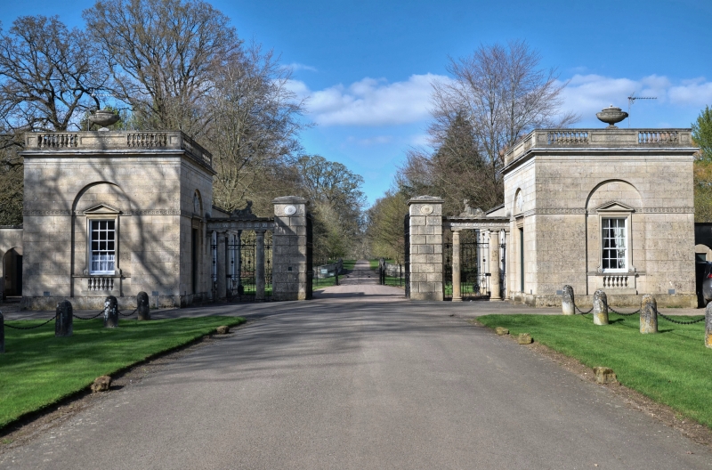
Lodge with gates and gatepier. Late C18. Architect Robert Mitchell.
Limestone ashlar. Lodge originally one-unit plan. Single storey. Central
sash window with glazing bars has balustrade below and pediment over; all
set in shallow arched recess. Door facing drive has 6 fielded panels with
moulded stone architraves set in similar shallow arch with shields of arms in
tympanums. Frieze cornice, panelled and balustraded parapet with large oval
urns over centre. Wrought iron gate to right hanging from rusticated pier
with moulded cornice and oval patrae flanked by Roman Doric 2-column open
screen with wrought iron panels and hand gates surmounted by entablature
with triglyph freize with sphinx over linking to flanking lodge. The lodge,
gates and gatepiers form a pair with the east lodge. They were moved to their
present position in 1938 from the Leicester Road.
(Buildings of England Northamptonshire, p.163).
Listing NGR: SP7087273648
External links are from the relevant listing authority and, where applicable, Wikidata. Wikidata IDs may be related buildings as well as this specific building. If you want to add or update a link, you will need to do so by editing the Wikidata entry.


Other nearby listed buildings
