Approximate Location Map
Large Map »
Latitude: 51.1838 / 51°11'1"N
Longitude: -3.4462 / 3°26'46"W
OS Eastings: 299018
OS Northings: 143726
OS Grid: SS990437
Mapcode National: GBR LK.5QRN
Mapcode Global: VH6GM.6HZV
Plus Code: 9C3R5HM3+GG
Entry Name: Dovecote
Listing Date: 22 May 1969
Grade: II*
Source: Historic England
Source ID: 1057581
English Heritage Legacy ID: 264714
Also known as: Dovecote 60m north of St George's Church
ID on this website: 101057581
Location: Dunster, Somerset, TA24
County: Somerset
District: Somerset West and Taunton
Civil Parish: Dunster
Built-Up Area: Dunster
Traditional County: Somerset
Lieutenancy Area (Ceremonial County): Somerset
Tagged with: Dovecote
SS 9843-9943
4/82
DUNSTER
PRIORY GREEN
Dovecote
22.5.69
GV
II*
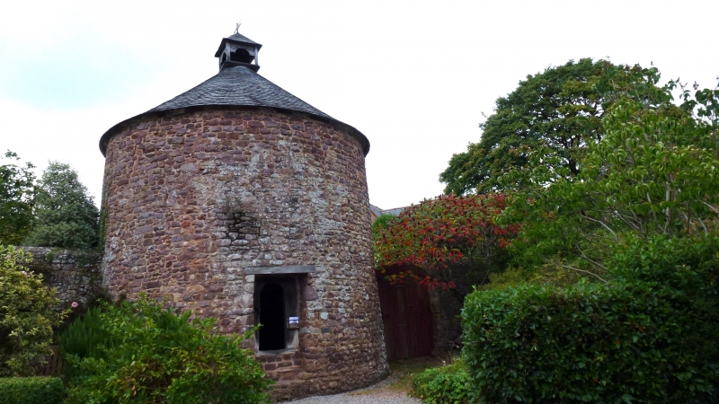
Good example of circular dovecote, probably late 16th century. Rubble, conical old slate roof with wooden exit turret. Small wood-framed door opening with pointed arch and door. Interior with potence (revolving wooden ladder). Scheduled Ancient Monument (Somerset County No 33).
Listing NGR: SS9902143724
External links are from the relevant listing authority and, where applicable, Wikidata. Wikidata IDs may be related buildings as well as this specific building. If you want to add or update a link, you will need to do so by editing the Wikidata entry.


Other nearby listed buildings
