Approximate Location Map
Large Map »
Latitude: 51.2871 / 51°17'13"N
Longitude: -2.8176 / 2°49'3"W
OS Eastings: 343078
OS Northings: 154540
OS Grid: ST430545
Mapcode National: GBR JF.Z1ZK
Mapcode Global: VH7CV.3XS4
Plus Code: 9C3V75PJ+VX
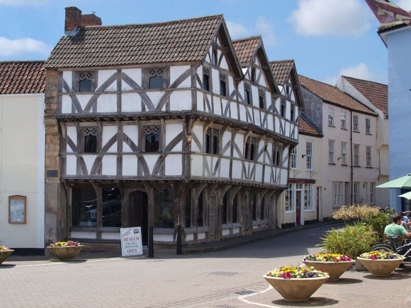
Entry Name: King John's Hunting Lodge (Axbridge Museum)
Listing Date: 9 February 1961
Last Amended: 29 January 1985
Grade: II*
Source: Historic England
Source ID: 1059142
English Heritage Legacy ID: 268654
Also known as: King John's Hunting Lodge, Axbridge
ID on this website: 101059142
Location: Axbridge, Somerset, BS26
County: Somerset
District: Sedgemoor
Civil Parish: Axbridge
Built-Up Area: Axbridge
Traditional County: Somerset
Lieutenancy Area (Ceremonial County): Somerset
Tagged with: House Inn Local museum
ST4354
12/2
AXBRIDGE
HIGH STREET (South side)
King John's Hunting Lodge (Axbridge Museum)
(formerly listed as The Square (South side))
9/2/61
GV
II*
Inn, now museum. Early C16, restored 1975. Timber framed with studding and prominent braces, continuous jetties to first and second floors with moulded rails on curved brackets; moulded corner post to left; moulded string to first floor; Three prominent gables with cusped bargeboards, double roman tile roof, brick stacks. Three storeys and attic; six single-light windows with ogee heads (a quatrefoil in a circle to each spandrel) to second floor; similar fenestration to first floor except the windows paired; a further window in the face of each gable; ground floor with six large C20 windows of a single pane each, inserted between the studs. Three door openings in surrounds with four-centred heads, ribbed doors. Return to The Square in similar style, two single-light ogee headed windows to each floor, except three large C20 windows to ground floor; ribbed door in a four-centred surround; section of coursed and squared rubble wall to left fording a narrow pier. Carved and painted wooden head formerly placed at the angle between The High Street and The Square now stored inside the building.
The building may have been shops with living accommodation over when first constructed. (V46 report, unpublished SRO, Autumn 1981).
Listing NGR: ST4307854540
External links are from the relevant listing authority and, where applicable, Wikidata. Wikidata IDs may be related buildings as well as this specific building. If you want to add or update a link, you will need to do so by editing the Wikidata entry.


Other nearby listed buildings
