Approximate Location Map
Large Map »
Latitude: 51.3184 / 51°19'6"N
Longitude: 0.8939 / 0°53'37"E
OS Eastings: 601750
OS Northings: 161679
OS Grid: TR017616
Mapcode National: GBR SW3.BSM
Mapcode Global: VHKJW.F4X3
Plus Code: 9F328V9V+9G
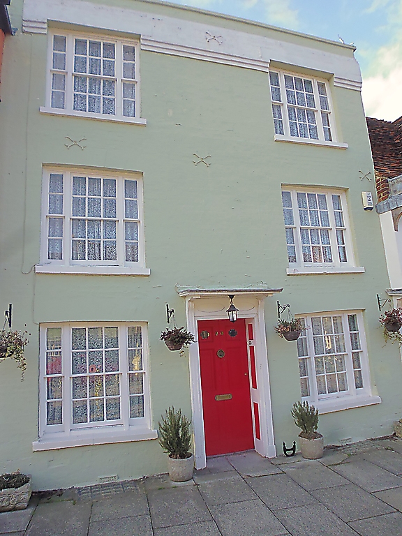
Entry Name: 20, Abbey Street
Listing Date: 4 May 1970
Grade: II
Source: Historic England
Source ID: 1061006
English Heritage Legacy ID: 175830
ID on this website: 101061006
Location: Faversham, Swale, Kent, ME13
County: Kent
District: Swale
Civil Parish: Faversham
Built-Up Area: Faversham
Traditional County: Kent
Lieutenancy Area (Ceremonial County): Kent
Tagged with: Building
ABBEY STREET
1.
l103 (West Side)
------------
No 20
Tn 0161 NE 1/79 4.5.70.
II GV
2.
Early Cl9, front to a Cl7 building. 3 storeys. 2 windows. Painted
brick. Parapet. Tiled roof. Glazing bars intact. Doorway in moulded
architrave surround with frieze, projecting cornice and door of 6
moulded panels.
Nos 14 to 32 (consec) form a group.
Listing NGR: TR0174161683
External links are from the relevant listing authority and, where applicable, Wikidata. Wikidata IDs may be related buildings as well as this specific building. If you want to add or update a link, you will need to do so by editing the Wikidata entry.


Other nearby listed buildings
