Approximate Location Map
Large Map »
Latitude: 51.4422 / 51°26'31"N
Longitude: -2.7184 / 2°43'6"W
OS Eastings: 350164
OS Northings: 171711
OS Grid: ST501717
Mapcode National: GBR JK.N8XG
Mapcode Global: VH88R.T0RR
Plus Code: 9C3VC7RJ+VJ
Entry Name: Home Farm Buildings
Listing Date: 29 April 2002
Grade: II*
Source: Historic England
Source ID: 1061341
English Heritage Legacy ID: 489524
ID on this website: 101061341
Location: Wraxall, North Somerset, BS48
County: North Somerset
Civil Parish: Wraxall and Failand
Traditional County: Somerset
Lieutenancy Area (Ceremonial County): Somerset
Tagged with: Building
WRAXALL AND FAILAND
121/0/10021 TYNTESFIELD PARK
29-APR-02 Home Farm Buildings
GV II*
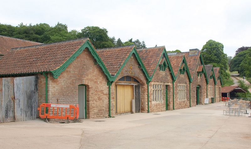
Planned farmstead /estate workshops. 1881; for Gibbs family [later Lord Wraxall] of Tyntesfield. Pink local stone with limestone door and window dressings, modern tile roofs, replacing slate.
PLAN: Built on two levels, with estate yard at upper level, divided from lower buildings by 2-storey feed store/mixing mill. At lower level covered yards around central midden.
Estate yard to north and at upper level, consists of range of open sheds along east side; feeding racks along the back of building show that it has been used for stock. Chimney in north gable, use unclear as interior not inspected. Western range consists of open timber store and workshop. Entrances to yard between two single-storey storage buildings along north side and at south end of west range between workshop and open shed abutting long main feed store/mixing mill along south side.
Feed store/mixing mill. Long building gabled to east and west and dividing the upper northern estate yard from the lower south-facing covered yards. At ground floor level in upper yard are three full-height double sliding doors opening onto yard, with separate mess room at east end entered through north-facing door and lit by a single window. Main part stone floored with shafting down length of building. This was connected through west gable to steam engine [now gone] which stood on the end of the building, and worked feed preparation machinery. The feed was then moved to stores below through shoots in the floor. This first floor is supported on arcading consisting of eight wide arches down the length of the building dividing the lower stores in half length-wise. The lower level consists of a series of feed stores, entered through doors opening south into the covered yards. The west end was most recently used for a bulk milk tank, and at the east end is a small vaulted feed [or root] store behind what were the piggeries.
Covered yards abut feed store to north and face south under five gables. A further two gables to the west front, a slaughter house and an originally open-fronted building under a stone arch. The ceiling of this section is plastered and the building is now filled with later stalling. These two western gabled buildings only extend northwards behind the continuous gabled facade about a third of the depth of the covered yards, the western slaughter house being slightly shorter than the open building, and they take the facade out beyond the feed store to the west. The main area of the covered yards and midden is behind five gables and runs the length of the feed store behind. The two western gables front the cow standings. Originally there were two rows with a feeding passage behind. The western one contains five cast-iron stalls by Musgrove [London and Belfast] at the north end with originally calf stall to the south. These calf stalls have been replaced by a further three cow standings. The eastern row was replaced by tubular steel stalls in the 1930s. The floor is modern concrete; the roof is two rows of six king-post trusses with diagonal boarding above. The valley between the two gables is supported on six cast-iron pillars made by Gardiners of Bristol. There is no obvious way of providing ventilation through the roof. The building is entered through a single-width door in the western gable and is lit by 4-light mullion windows under each of the two gables. There are decorative round windows in the gables above, under shallow canopies.
The central, slightly wider, gable fronted the midden. Double doors open south, with a decorative round window under a shallow canopy above, and the square base for a decorative cupola or weather vane at the gable apex. Inside the double door a cobbled way slopes down into a midden, which is surrounded by a curbed channel and a walk-way. The midden does not run the full depth of the building and is surrounded to the north and west by a modern wall. Originally it would have been open to the rest of the cow house and the valleys between the gables are supported by four cast-iron Gardiner's pillars down each side. Along the north end are five Musgroves cow stalls. The roof is supported by wide span trusses.
The two eastern gables front what was originally the calf-houses and piggeries. The piggeries have been removed and calf stalls extended to take up all the building. These consist of wooden boxes topped by cast-iron railings. A row of six cast-iron Gadiner's pillars runns the length of the building under the valley and the roof matches that at the west end, except that ventilation louvres in the roof were part of the original design. 6-, 2- and 3-light mullion windows run the length of the east wall; the building is entered from the south through a door at the east end of the east gable and there are 4-light stone mullion windows in the gables with decorative round windows under shallow canopies above.
To the south is a bacon curing house and the foundations of an octagonal dairy, indicating that this was primarily a dairy farm, where a prize herd of Alderney cows was kept, and the by-products of the dairy were fed to pigs.
An unusually good example of a Victorian planned farmstead with a covered yard, combining all the main operations under one roof.
External links are from the relevant listing authority and, where applicable, Wikidata. Wikidata IDs may be related buildings as well as this specific building. If you want to add or update a link, you will need to do so by editing the Wikidata entry.


Other nearby listed buildings
