Approximate Location Map
Large Map »
Latitude: 51.3352 / 51°20'6"N
Longitude: 0.0297 / 0°1'46"E
OS Eastings: 541487
OS Northings: 161527
OS Grid: TQ414615
Mapcode National: GBR N0.L4X
Mapcode Global: VHHP9.GPKS
Plus Code: 9F3282PH+3V
Entry Name: The Kings Arms
Listing Date: 29 June 1973
Grade: II
Source: Historic England
Source ID: 1064393
English Heritage Legacy ID: 358513
Also known as: Kings Arms, Leaves Green
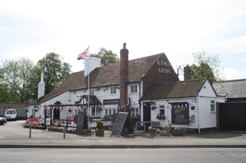
Kings Arms
The Kings Arms, Leaves Green, Keston
ID on this website: 101064393
Location: Leaves Green, Bromley, London, BR2
County: London
District: Bromley
Electoral Ward/Division: Darwin
Parish: Non Civil Parish
Built-Up Area: Biggin Hill
Traditional County: Kent
Lieutenancy Area (Ceremonial County): Greater London
Church of England Parish: Biggin Hill St Mark
Church of England Diocese: Rochester
Tagged with: Pub
LEAVES GREEN ROAD,
1.
4407 LEAVES GREEN
The King's Arms
TQ 46 SW 12/183
II
2.
C18 or older weatherboarded, structure. 3 windows. Ground floor has C19
extensions. Sliding casements and a C19 porch. Modern chimney stack.
Listing NGR: TQ4148761527
External links are from the relevant listing authority and, where applicable, Wikidata. Wikidata IDs may be related buildings as well as this specific building. If you want to add or update a link, you will need to do so by editing the Wikidata entry.


Other nearby listed buildings
