Approximate Location Map
Large Map »
Latitude: 51.4526 / 51°27'9"N
Longitude: -0.1498 / 0°8'59"W
OS Eastings: 528654
OS Northings: 174246
OS Grid: TQ286742
Mapcode National: GBR F2.8WK
Mapcode Global: VHGR5.CR49
Plus Code: 9C3XFV32+23
Entry Name: Broadoak
Listing Date: 14 July 1955
Grade: II
Source: Historic England
Source ID: 1065506
English Heritage Legacy ID: 207082
ID on this website: 101065506
Location: Clapham Common, Wandsworth, London, SW4
County: London
District: Wandsworth
Electoral Ward/Division: Balham
Parish: Non Civil Parish
Built-Up Area: Wandsworth
Traditional County: Surrey
Lieutenancy Area (Ceremonial County): Greater London
Church of England Parish: Balham Hill The Ascension
Church of England Diocese: Southwark
Tagged with: Building
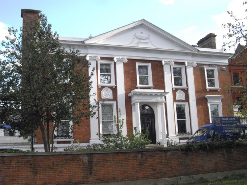
1. NIGHTINGALE LANE SW12
5033
Nos 9 and 11
(Broadoak)
TQ 2874 13/18 14.7.55
II
2.
Later half 18th Century. Altered. Two-storey and basement. Five window. Red
brick front (stucco basement). Dentil entablature. Centre bay (3 windows) with
stone Ionic pilasters and pediment. Doric porch with triglyphs and mutule cornice.
Good interior features.
Listing NGR: TQ2865474246
External links are from the relevant listing authority and, where applicable, Wikidata. Wikidata IDs may be related buildings as well as this specific building. If you want to add or update a link, you will need to do so by editing the Wikidata entry.


Other nearby listed buildings
