Approximate Location Map
Large Map »
Latitude: 51.821 / 51°49'15"N
Longitude: -0.6887 / 0°41'19"W
OS Eastings: 490477
OS Northings: 214406
OS Grid: SP904144
Mapcode National: GBR F47.STX
Mapcode Global: VHFRP.0HRD
Plus Code: 9C3XR8C6+9G
Entry Name: Grand Union Canal Aylesbury Arm Bridge Number 3 (Wilstone Bridge) and Lock Number 8 Adjoining on East
Listing Date: 29 May 1986
Grade: II
Source: Historic England
Source ID: 1067803
English Heritage Legacy ID: 355764
ID on this website: 101067803
TRING RURAL GRAND UNION CANAL-
SP 9014
AYLESBURY ARM
9/128 Bridge No. 3
- (Wilstone Bridge) and
Lock No. 8 adjoining
on East
GV II
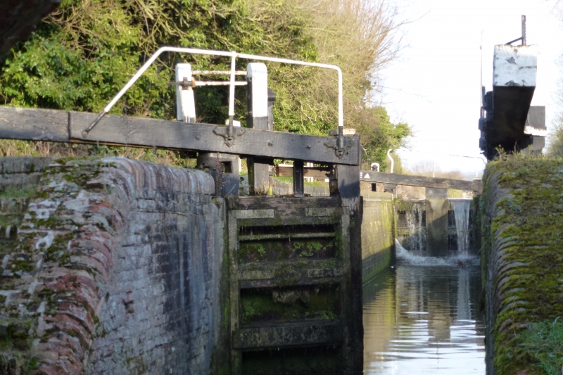
Canal bridge and adjoining lock. 1811-13. Engineer Henry Provis for
Grand Junction Canal Company. Bridge of red brick in English-bond with
granite capping to piers terminating parapet. Lock of plum brick with
brick and granite copings, timber gates, and cast iron domed bollards. A
narrow hump-backed bridge carrying Tring Road over canal. Horseshoe arch
with 9 inch arch-ring. Battered side-walls topped by raised band of 4
courses at roadway level and parapet walls with courses following the
hump. Square projecting end piers terminate the outswept ends of the
parapets. Repairs in buff brick where tow-ropes have cut into brickwork
of arch next towpath. Little altered since arm opened in 1815. Narrow
lock to take a single narrowboat has its lower end close to E side of
bridge. Double gates to lower end with gate-paddles only. Single gate at
upper end hinged on N side of lock. This end has ground paddles only,
with gear set on timber posts. Stone edging extends about 8M to E of
entrance. Dated cast iron hinge anchor plates (1866, 1866 at W:1854 at
E) are probably re-used from elsewhere. (Branch Johnson(1970)118-9,122:
Faulkner(1972)92).
Listing NGR: SP9047714406
External links are from the relevant listing authority and, where applicable, Wikidata. Wikidata IDs may be related buildings as well as this specific building. If you want to add or update a link, you will need to do so by editing the Wikidata entry.


Other nearby listed buildings
