Approximate Location Map
Large Map »
Latitude: 53.3618 / 53°21'42"N
Longitude: -2.9117 / 2°54'42"W
OS Eastings: 339421
OS Northings: 385381
OS Grid: SJ394853
Mapcode National: GBR 8Y3K.DL
Mapcode Global: WH87G.7RQM
Plus Code: 9C5V936Q+P8
Entry Name: St Austin's Parish Hall
Listing Date: 19 June 1985
Grade: II
Source: Historic England
Source ID: 1068403
English Heritage Legacy ID: 213623
ID on this website: 101068403
Location: Grassendale, Liverpool, Merseyside, L19
County: Liverpool
Electoral Ward/Division: Cressington
Parish: Non Civil Parish
Built-Up Area: Liverpool
Traditional County: Lancashire
Lieutenancy Area (Ceremonial County): Merseyside
Church of England Parish: Grassendale St Mary the Virgin
Church of England Diocese: Liverpool
Tagged with: School building Church hall
SJ 3985 AIGBURTH ROAD
L19
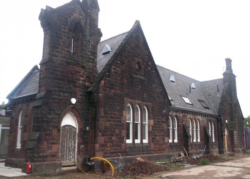
46/32 St. Austin's
Parish Hall
G.V. II
School, now parish hall. Dated 1860 on plaque. Stone
with slate roof. One storey, 3 bays, end bays break forward
under gables, 2 and 3-light mullioned windows. Doorway at left
end under buttressed belfry with pinnacle.
Listing NGR: SJ3942185381
External links are from the relevant listing authority and, where applicable, Wikidata. Wikidata IDs may be related buildings as well as this specific building. If you want to add or update a link, you will need to do so by editing the Wikidata entry.


Other nearby listed buildings
