Approximate Location Map
Large Map »
Latitude: 51.0674 / 51°4'2"N
Longitude: 0.6838 / 0°41'1"E
OS Eastings: 588135
OS Northings: 133212
OS Grid: TQ881332
Mapcode National: GBR QW8.5NW
Mapcode Global: FRA D6B9.D6R
Plus Code: 9F323M8M+XG
Entry Name: 106, High Street
Listing Date: 8 June 1972
Grade: II
Source: Historic England
Source ID: 1070352
English Heritage Legacy ID: 179767
ID on this website: 101070352
Location: Tenterden, Ashford, Kent, TN30
County: Kent
District: Ashford
Civil Parish: Tenterden
Built-Up Area: Tenterden
Traditional County: Kent
Lieutenancy Area (Ceremonial County): Kent
Tagged with: Building
1.
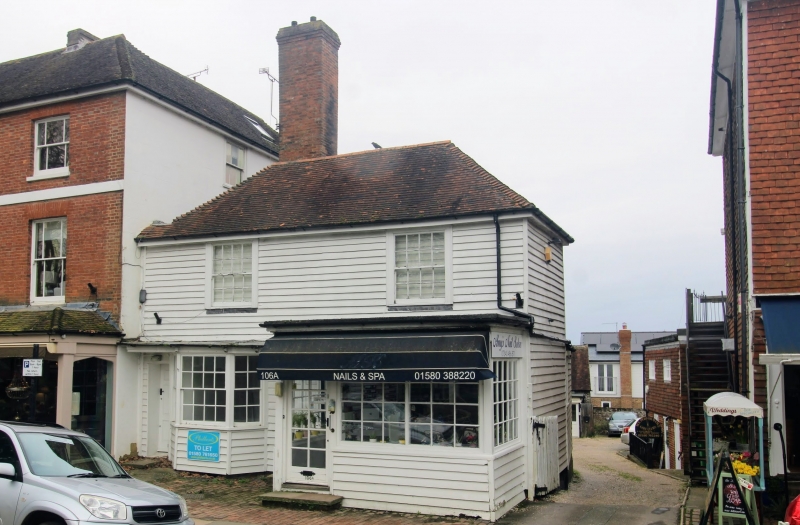
1715 HIGH STREET
(North Side)
No 106
TQ 8833 1/52
II GV
2.
C18. 2 storeys timber framed faced with weatherboarding. Hipped tiled roof
with eaves cornice. 2 sashes with glazing bars intact. One bay window on
the ground floor, the other cut away to form a modern shop front.
Nos 102 to 106 (even) form a group.
Listing NGR: TQ8813433211
External links are from the relevant listing authority and, where applicable, Wikidata. Wikidata IDs may be related buildings as well as this specific building. If you want to add or update a link, you will need to do so by editing the Wikidata entry.


Other nearby listed buildings
