Approximate Location Map
Large Map »
Latitude: 51.0524 / 51°3'8"N
Longitude: 0.6297 / 0°37'46"E
OS Eastings: 584404
OS Northings: 131409
OS Grid: TQ844314
Mapcode National: GBR QW6.XPM
Mapcode Global: FRA D66B.P4G
Plus Code: 9F323J2H+XV
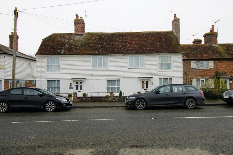
Entry Name: 32 and 34, High Street
Listing Date: 16 August 1962
Grade: II
Source: Historic England
Source ID: 1070921
English Heritage Legacy ID: 180338
ID on this website: 101070921
Location: Rolvenden, Ashford, Kent, TN17
County: Kent
District: Ashford
Civil Parish: Rolvenden
Built-Up Area: Rolvenden
Traditional County: Kent
Lieutenancy Area (Ceremonial County): Kent
Tagged with: Building
ROLVENDEN HIGH STREET
1.
5272 (west side)
Nos 32 and 34
TQ.8451 18/294 16.8.62. 32 ar.d 34
II GV
2.
C18 range. Two storeys. Ground floor painted brick above weatherboarded.
Tiled roof, half-hipped at one end. Four windows in all. Sash windows with
vertical glazing bars intact or restored.
Listing NGR: TQ8440231404
External links are from the relevant listing authority and, where applicable, Wikidata. Wikidata IDs may be related buildings as well as this specific building. If you want to add or update a link, you will need to do so by editing the Wikidata entry.


Other nearby listed buildings
