Approximate Location Map
Large Map »
Latitude: 51.0413 / 51°2'28"N
Longitude: 0.7411 / 0°44'28"E
OS Eastings: 592258
OS Northings: 130457
OS Grid: TQ922304
Mapcode National: GBR RXW.N5V
Mapcode Global: FRA D6FC.JJX
Plus Code: 9F322PRR+GC
Entry Name: Skeers House
Listing Date: 8 June 1972
Grade: II
Source: Historic England
Source ID: 1071154
English Heritage Legacy ID: 179797
ID on this website: 101071154
Location: Reading Street, Ashford, Kent, TN30
County: Kent
District: Ashford
Civil Parish: Tenterden
Traditional County: Kent
Lieutenancy Area (Ceremonial County): Kent
Tagged with: House
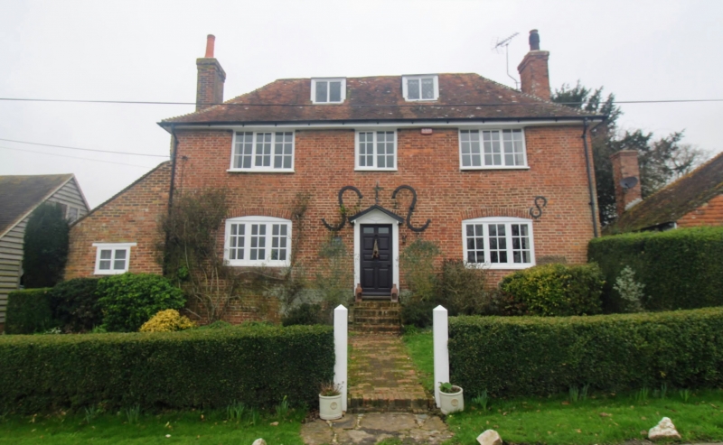
1.
1715 READING STREET
(South West Side)
Skeers House
TQ 93 SW 6/152
II GV
2.
Early C18. 2 storeys and attic red brick. Roof has 2 dormers and eaves
cornice. 3 casements, those on the ground floor with cambered head linings.
Doorcase with pediment-shaped hood over.
Ebony Cottage, Wellbro Cottage, Skeers House & Old Barrack Farm form a group.
Listing NGR: TQ9225830457
External links are from the relevant listing authority and, where applicable, Wikidata. Wikidata IDs may be related buildings as well as this specific building. If you want to add or update a link, you will need to do so by editing the Wikidata entry.


Other nearby listed buildings
