Approximate Location Map
Large Map »
Latitude: 54.171 / 54°10'15"N
Longitude: -2.5938 / 2°35'37"W
OS Eastings: 361329
OS Northings: 475182
OS Grid: SD613751
Mapcode National: GBR BNB6.7L
Mapcode Global: WH94W.4F39
Plus Code: 9C6V5CC4+9F
Entry Name: Milestone
Listing Date: 4 December 1985
Grade: II
Source: Historic England
Source ID: 1071709
English Heritage Legacy ID: 182344
ID on this website: 101071709
Location: Nether Burrow, Lancaster, Lancashire, LA6
County: Lancashire
District: Lancaster
Civil Parish: Burrow-with-Burrow
Traditional County: Lancashire
Lieutenancy Area (Ceremonial County): Lancashire
Church of England Parish: Tunstall St John the Baptist and Melling St Wilfred and Leck St Peter
Church of England Diocese: Blackburn
Tagged with: Milestone
SD 67 NW
2/50
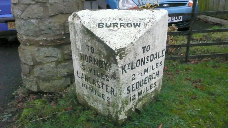
BURROW-WITH-BURROW
A683
Milestone
II
Milestone, mid C19th, sandstone. Of triangular plan with sloping top
inscribed: 'BURROW.' Left-hand face inscribed: 'TO HORNBY 5 MILES.
LANCASTER 14 MILES.' Right-hand face inscribed: TO Ky LONSDALE 2½ MILES.
SEDBERGH 12 MILES.'
Listing NGR: SD6132975182
External links are from the relevant listing authority and, where applicable, Wikidata. Wikidata IDs may be related buildings as well as this specific building. If you want to add or update a link, you will need to do so by editing the Wikidata entry.


Other nearby listed buildings
