Approximate Location Map
Large Map »
Latitude: 51.2534 / 51°15'12"N
Longitude: 0.3229 / 0°19'22"E
OS Eastings: 562198
OS Northings: 153032
OS Grid: TQ621530
Mapcode National: GBR NPT.BG2
Mapcode Global: VHHPV.KR2J
Plus Code: 9F32783F+95
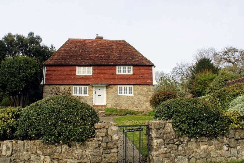
Entry Name: Croucher's Cottage
Listing Date: 3 May 1984
Grade: II
Source: Historic England
Source ID: 1072696
English Heritage Legacy ID: 357365
ID on this website: 101072696
Location: Roughway, Tonbridge and Malling, Kent, TN11
County: Kent
District: Tonbridge and Malling
Civil Parish: Plaxtol
Traditional County: Kent
Lieutenancy Area (Ceremonial County): Kent
Church of England Parish: Plaxtol
Church of England Diocese: Rochester
Tagged with: Cottage
TQ 65 SW PLAXTOL ROUGHWAY LANE
4/28 (north side)
Croucher's Cottage
II
Cottage. C18 framed structure. Random rubble stone ground floor, tile-hung first
floor. Hipped plain tiled roof with stack off-ridge to rear. Two storeys. Two
windows casements. Central boarded with flat hood on brackets up 6 steps. Included
as a good example of modest domestic building of traditional regional type.
Listing NGR: TQ6219853032
External links are from the relevant listing authority and, where applicable, Wikidata. Wikidata IDs may be related buildings as well as this specific building. If you want to add or update a link, you will need to do so by editing the Wikidata entry.


Other nearby listed buildings
