Approximate Location Map
Large Map »
Latitude: 51.3163 / 51°18'58"N
Longitude: 0.8878 / 0°53'16"E
OS Eastings: 601341
OS Northings: 161427
OS Grid: TR013614
Mapcode National: GBR SW3.H8X
Mapcode Global: VHKJW.B5QR
Plus Code: 9F328V8Q+G4
Entry Name: 33, West Street
Listing Date: 3 August 1972
Grade: II
Source: Historic England
Source ID: 1074914
English Heritage Legacy ID: 438539
ID on this website: 101074914
Location: Faversham, Swale, Kent, ME13
County: Kent
District: Swale
Civil Parish: Faversham
Built-Up Area: Faversham
Traditional County: Kent
Lieutenancy Area (Ceremonial County): Kent
Tagged with: Building
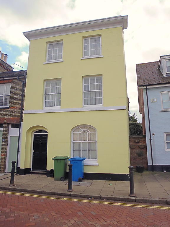
WEST STREET
1.
ll03 (South Side)
------------
No 33
TR 0161 SW 2/306
II
2.
Early C19. 3 storeys. 2 bays. Rendered. Cornice and parapet. Band at
1st floor sill level. Flash windows in reveals; glazing bars intact. On
ground floor, elliptical headed sash window in reveals to right hand; to
left hand, elliptical headed doorway; 6 panelled door with 4 moulded
panels, in reveals; small elliptical fanlight over.
Listing NGR: TR0134161427
External links are from the relevant listing authority and, where applicable, Wikidata. Wikidata IDs may be related buildings as well as this specific building. If you want to add or update a link, you will need to do so by editing the Wikidata entry.


Other nearby listed buildings
