Approximate Location Map
Large Map »
Latitude: 52.2471 / 52°14'49"N
Longitude: 0.7216 / 0°43'17"E
OS Eastings: 585891
OS Northings: 264480
OS Grid: TL858644
Mapcode National: GBR QF0.386
Mapcode Global: VHKD4.GSB7
Plus Code: 9F426PWC+RJ
Entry Name: 18, Eastgate Street
Listing Date: 7 August 1952
Last Amended: 30 October 1997
Grade: II
Source: Historic England
Source ID: 1075233
English Heritage Legacy ID: 466806
ID on this website: 101075233
Location: Bury St Edmunds, West Suffolk, IP33
County: Suffolk
District: West Suffolk
Civil Parish: Bury St Edmunds
Built-Up Area: Bury St Edmunds
Traditional County: Suffolk
Lieutenancy Area (Ceremonial County): Suffolk
Church of England Parish: Bury St Edmunds St John the Evangelist
Church of England Diocese: St.Edmundsbury and Ipswich
Tagged with: Building
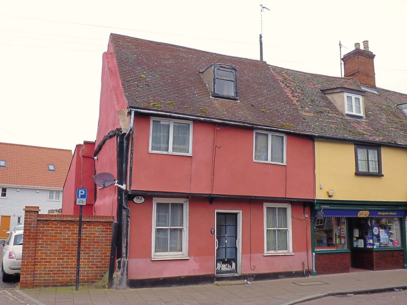
BURY ST EDMUNDS
TL8564SE EASTGATE STREET
639-1/8/335 (North side)
07/08/52 No.18
(Formerly Listed as:
EASTGATE STREET
(North side)
Nos.18-22 (Consecutive))
GV II
House. Late C16/early C17. Timber-framed and rendered; C20
plaintiles.
EXTERIOR: 2 storeys and attics; 2 bays, jettied along front. 2
windows to each storey: C20 plain 2-light casements to the 1st
storey and sashes in flush cased frames with a single vertical
glazing-bar to the ground storey. A segmental-headed
lead-covered dormer has a single C20 standard window with
fanlight.
Central doorway in a plain wood doorcase. Against the west
gable is the end truss of the now-demolished house which stood
to the west of No.18, with the main components of the frame
and no evidence of studding.
INTERIOR: plain timbers exposed in the ground storey ceilings.
A chimney-stack on the back wall of the eastern bay was linked
with the rear range, but has now been almost entirely removed,
apart from the lintel. Neither end wall of the house appears
to have original studding: on the west, this makes a curious
join with the former house there; on the east, a small gap
between the end cross-beam and the wall indicates that the
studding there relates to the next house eastwards. The rear
range is in 2 stages of building.
Listing NGR: TL8589164480
External links are from the relevant listing authority and, where applicable, Wikidata. Wikidata IDs may be related buildings as well as this specific building. If you want to add or update a link, you will need to do so by editing the Wikidata entry.


Other nearby listed buildings
