Approximate Location Map
Large Map »
Latitude: 52.4089 / 52°24'31"N
Longitude: -1.5091 / 1°30'32"W
OS Eastings: 433488
OS Northings: 279096
OS Grid: SP334790
Mapcode National: GBR HFM.GH
Mapcode Global: VHBWY.SQK7
Plus Code: 9C4WCF5R+G9
Entry Name: Remains of the west front, nave and aisles of Coventry Priory
Listing Date: 5 February 1955
Last Amended: 29 August 2019
Grade: I
Source: Historic England
Source ID: 1076588
English Heritage Legacy ID: 218543
Also known as: Priory ruins
Coventry Priory
ID on this website: 101076588
Location: Coventry, West Midlands, CV1
County: Coventry
Electoral Ward/Division: St Michael's
Parish: Non Civil Parish
Built-Up Area: Coventry
Traditional County: Warwickshire
Lieutenancy Area (Ceremonial County): West Midlands
Church of England Parish: Coventry Holy Trinity
Church of England Diocese: Coventry
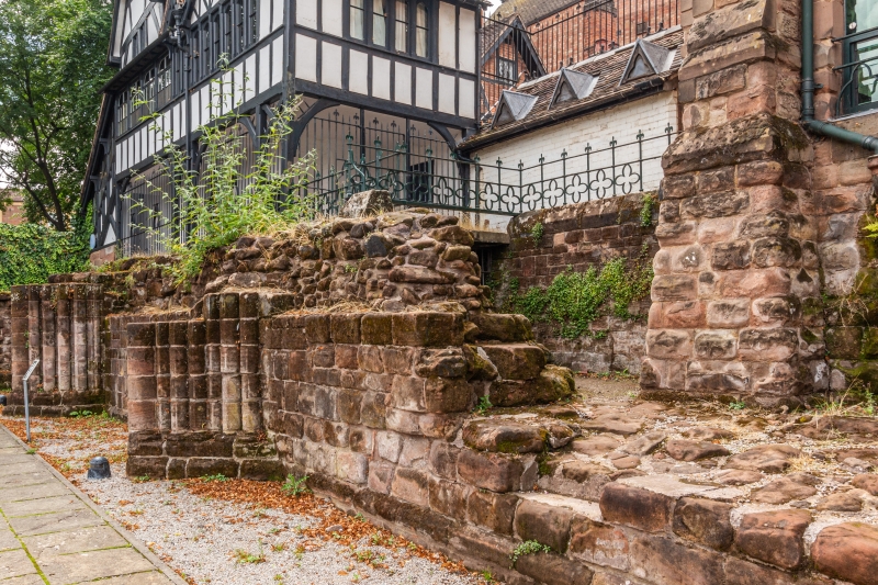
The remains of the west front, nave and aisles of the medieval cathedral of Coventry Priory.
The remains of the west front, nave and aisles of the medieval cathedral of Coventry Priory.
MATERIALS: the surviving fabric of the church is in red sandstone.
PLAN: the surviving west front of the church runs north-south adjacent to the buildings of 3-5 Priory Row and the former Blue Coat School. The site of the nave is adjacent to the east, with aisles to both sides.
DESCRIPTION: the lower portion of the west front of the cathedral runs along the western edge of what is now Priory Gardens. The eastern, inside face of the west wall is exposed while the former outside face is buried (although partially visible in the cellar of Blue Coat School). The inside face has deeply-moulded piers and a central opening where the west door gave access to the nave down an arc of steps. Part of the south-west tower, the west wall and part of a spiral staircase survive. The north-west tower has arches at its lowest level which give access to a room at the base of the tower, and the spiral staircase within now gives access to the former Blue Coat School building.
The area of the nave and aisles is now laid out as Priory Gardens, with parts of the surviving fabric consolidated. The lower courses of the south wall of the cathedral are visible, with shallow external buttresses. The north wall, which divided the nave from the cloister beyond, partially survives and is visible within the Priory Visitor Centre. The locations of ten of the piers of the nave arcade are identified within Priory Gardens; six of these have glass boxes displaying fragments of stone found during the Phoenix Initiative. Areas in the nave are laid to gravel and grass with paved paths around the site.
The first recorded event in the history of Coventry is the dedication of a church and abbey on 4 October 1043 when a Benedictine house for an abbot and 24 monks was established under the patronage of Leofric, Earl of Mercia, and his wife, Lady Godiva. There is a tradition of an earlier nunnery on the site, and excavations in the cloister found a burial dating from the late C9; tradition has it that this nunnery was destroyed by Danish raiders in 1016. The abbey took on cathedral status in 1102 when Robert de Limsey transferred his See from Chester to Coventry; becoming the Cathedral and Priory of St Mary, referred to here as Coventry Priory, and then marked the beginning of the joint bishopric of Coventry and Lichfield.
As with most monastic complexes, the construction of the buildings took many years. Little is known about the earlier buildings on the site, but building of the new cathedral is evident from the early C12, beginning with the chancel at the east end. Romanesque features have been found which date from around 1115-1140 and support this development. Work appears to have been halted in the mid-C12 when the site was partially fortified by nobleman Robert Marmion who laid siege to the nearby castle belonging to the Earl of Chester. Construction resumed after around 1150 and continued into the C13; the remains of the west end of the cathedral have been dated to the second quarter of the C13, with evidence from the nave showing it to have been in the Early English style.
The site of the cathedral and Benedictine priory covered approximately 13 acres of their hilltop site. At its greatest extent, the medieval cathedral measured approximately 130m in length: it stretched from the surviving remains of the west front to the exposed remains of the eastern chapels which are visible adjacent to the present cathedral. The west front of the cathedral had two towers, both thought to have had spires, a long nave and two transepts. The central crossing tower is also thought to have had a spire. To the north was the usual arrangement of cloister, chapter house and refectory, with infirmary and dormitory ranges beyond that. The site is stepped, with the cathedral itself the highest point of the site (Holy Trinity Church to the south stands at the top of the hill) and the other areas stepping down the hill to the north.
The bishop's seat at Coventry was transferred by the C14 to nearby Lichfield, lessening the importance of Coventry at that time. The Priory was dissolved by Henry VIII and the monks were expelled on 15 January 1539 when the last Prior surrendered the monastic house. Several unsuccessful attempts were made by the mayor and aldermen, as well as the Bishop of Coventry and Lichfield, to save the cathedral. These were in vain. The priory buildings were not immediately demolished, and it seems were largely still standing when the site was sold in 1545 with the Crown retaining ownership of the materials of all the buildings. In the 1570s, the site was acquired by the Corporation of Coventry, who then set about selling off as much of the surviving material as they could. William Smyth's sketch of Coventry of 1576 suggests the crossing tower of the cathedral survived at that date, but by the time of John Speed's map of around 1610, the site is shown as a pile of rubble, although the precinct gate appears to survive.
From the Dissolution onwards, the site of the cathedral seems to have changed hands numerous times and been subject to various uses, including for housing animals by the proprietors of Butcher Row. The north-west tower of the cathedral survived and appears to have been a dwelling, before later being used by the Blue Coat School. Other dwellings were built around the site, and the nave was partially used as garden space with a bowling green on the site of the cloister. The Bradford map of 1758 shows the north side of Priory Row entirely built upon. These properties were later acquired by Holy Trinity Church, demolished, and the site of the nave consecrated for use as a burial ground in around 1776. The burial ground covered the whole of the area of the former nave and aisles of the cathedral; in the mid-C19 a brick and timber bell tower was erected, but later demolished.
The cathedral site has been investigated and excavated numerous times since the 1850s. During work for the rebuilding of the Blue Coat School and restoration of the Lychgate Cottages around this time, the remains of the west front of the cathedral were discovered and exposed. They lay in a deep ditch the result of the adjacent to the burial ground. Further limited excavations took place in the mid-C20, before a substantial excavation as part of the Phoenix Initiative between 1999 and 2003. This involved the excavation of the nave tot he west of the crossing, including the removal of nearly 2000 burials from the churchyard, parts of the crossing and north transept, and parts of the cloister, refectory and chapter house. Excavation of the nave found evidence pointing to the architecture of the nave arcade changing from Romanesque to Early English, and for the vaulting of the north aisle roof. Painted stonework was recovered with expensive pigments of the late-medieval period, including vermillion and gold leaf. Much rubble was found in the space of the nave itself, but no stone vaulting, suggesting that the nave had a timber roof. Much floor material was recovered, including floor tiles and sandstone flags, and a number of burials.
During this project, the extensive undercrofts north of the chapter house were discovered and conserved for display, with a new building built above. Following the project, the nave was laid out as a public garden with a new visitor centre built in the cloister, and the cloister garth serving as a garden for the visitor centre. The areas of the crossing and north transept were returned to use as private gardens to the buildings on Priory Row. The choir and eastern end of the cathedral have not been excavated, apart from the Chevet chapels at the far end which were exposed during the construction of the present cathedral in 1955.
The remains of the west front, nave and aisles of the medieval cathedral of Coventry Priory are listed at Grade I for the following principal reasons:
Architectural interest:
* as the surviving physical fabric of the nave and aisles of the Cathedral of St Mary, part of Coventry Priory;
* for the evidence the remains possess which shows the architectural style and development of the cathedral building;
* for the quality of the surviving stonework.
Historic interest:
* as the surviving remains of the principal part of Coventry Priory and its long history at the heart of the city of Coventry;
Group value:
* with the other component parts of the Priory site and surrounding listed buildings, including the later and present cathedrals.
External links are from the relevant listing authority and, where applicable, Wikidata. Wikidata IDs may be related buildings as well as this specific building. If you want to add or update a link, you will need to do so by editing the Wikidata entry.


Other nearby listed buildings
