Approximate Location Map
Large Map »
Latitude: 51.3903 / 51°23'25"N
Longitude: 0.4003 / 0°24'1"E
OS Eastings: 567101
OS Northings: 168434
OS Grid: TQ671684
Mapcode National: GBR NN6.L25
Mapcode Global: VHJLR.WBH0
Plus Code: 9F329CR2+44
Entry Name: 26-30, the Street
Listing Date: 23 February 1981
Grade: II
Source: Historic England
Source ID: 1076989
English Heritage Legacy ID: 356750
ID on this website: 101076989
Location: Cobham, Gravesham, Kent, DA12
County: Kent
District: Gravesham
Civil Parish: Cobham
Built-Up Area: Cobham
Traditional County: Kent
Lieutenancy Area (Ceremonial County): Kent
Church of England Parish: Cobham St Mary Magdalene
Church of England Diocese: Rochester
Tagged with: Building
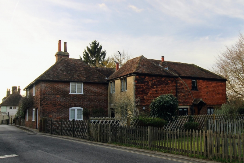
TQ 66 NE COBHAM THE STREET
5/40 (north side)
23.2.81 Nos 26 to 30 (even)
II
Group of cottages in L-shaped block. C18. Two storeys mainly brick with ashlar stone
facing to recessed east end. Hipped tiled roof. Casement windows. Fragments of old
timber-framing internally.
Listing NGR: TQ6710568437
External links are from the relevant listing authority and, where applicable, Wikidata. Wikidata IDs may be related buildings as well as this specific building. If you want to add or update a link, you will need to do so by editing the Wikidata entry.


Other nearby listed buildings
