Approximate Location Map
Large Map »
Latitude: 51.8379 / 51°50'16"N
Longitude: -0.0157 / 0°0'56"W
OS Eastings: 536810
OS Northings: 217335
OS Grid: TL368173
Mapcode National: GBR KB7.NW5
Mapcode Global: VHGPH.P22F
Plus Code: 9C3XRXQM+4P
Entry Name: Remains of Old Church of St Mary and All Saints
Listing Date: 24 January 1967
Grade: II*
Source: Historic England
Source ID: 1077953
English Heritage Legacy ID: 356028
ID on this website: 101077953
Location: Cold Christmas, East Hertfordshire, SG12
County: Hertfordshire
District: East Hertfordshire
Civil Parish: Thundridge
Traditional County: Hertfordshire
Lieutenancy Area (Ceremonial County): Hertfordshire
Tagged with: Architectural structure
TL 31NE THUNDRIDGE OLD CHURCH LANE
(north side)
Thundridge Bury
2/19 Remains of Old Church of
St Mary and All Saints
24.1.67
II*
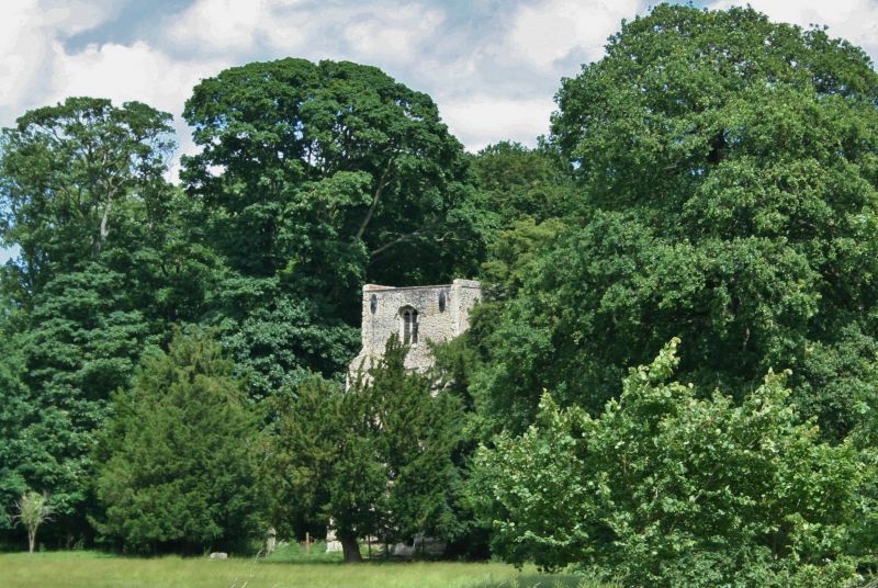
Church. W tower only remains. C15 tower with C12 doorway and C14
window set in blocking of tower arch when church demolished in
1853. Flint rubble with stone dressings and clunch moulded
frames to openings. Roofed by a concrete slab at former parapet
level. A tall 3-stage square W tower with diagonal buttreses at
W corners. An internal spiral stair rises in the SW corner. W
front has weathered string courses at each level with sloped
plinth and protecting string course just above it. 3-light
cusped C15 W window immediately over contemporary W door with 4
centred depressed head, hollow moulded jambs, spandrels, square
surround and moulded label with grotesque heads as stops.
Pointed loop to middle stage and 2-light traceried openings on
each face of the bell stage. Large oval cast-iron tie plates at
2 levels on side walls. Chevron and dogtooth moulded arch and 2-
light square headed, ogee traceried window with ferramenta and
label with caved headstops, in blocking of equilateral C15 tower
arch with hollow moulded imposts. Frame of hatchment fixed hiqh
inside tower. Quatrefoil in circle dial stone on S face of
tower. Stone slab dial fixed higher up on same face. Many
carved C18 gravestones in surrounding churchyard with C17 and C18
brick wall. (RCHM (1911) 221: VCH (1912) 379: Pevsner (1977)
364).
Listing NGR: TL3681017335
External links are from the relevant listing authority and, where applicable, Wikidata. Wikidata IDs may be related buildings as well as this specific building. If you want to add or update a link, you will need to do so by editing the Wikidata entry.


Other nearby listed buildings
