Approximate Location Map
Large Map »
Latitude: 51.7852 / 51°47'6"N
Longitude: 0.014 / 0°0'50"E
OS Eastings: 539015
OS Northings: 211533
OS Grid: TL390115
Mapcode National: GBR KC1.4B1
Mapcode Global: VHHM5.6D7B
Plus Code: 9F32Q2P7+3H
Entry Name: The Baish Almshouses and Attached Forecourt Wall
Listing Date: 4 December 1951
Grade: II*
Source: Historic England
Source ID: 1078739
English Heritage Legacy ID: 355963
ID on this website: 101078739
Location: Stanstead Abbotts, East Hertfordshire, SG12
County: Hertfordshire
District: East Hertfordshire
Civil Parish: Stanstead Abbots
Built-Up Area: St Margarets
Traditional County: Hertfordshire
Lieutenancy Area (Ceremonial County): Hertfordshire
Church of England Parish: Stanstead Abbots
Church of England Diocese: St.Albans
Tagged with: Almshouse
TL 31NW STANSTEAD ABBOTS ROYDON ROAD
(south side)
Stanstead Abbots village
5/51 Nos 79 to 89 (odd)
(The Baish Almshouses)
and attached forecourt
4.12.51 wall)
(Formerly listed as The Baish's
GV Almhouses)
II*
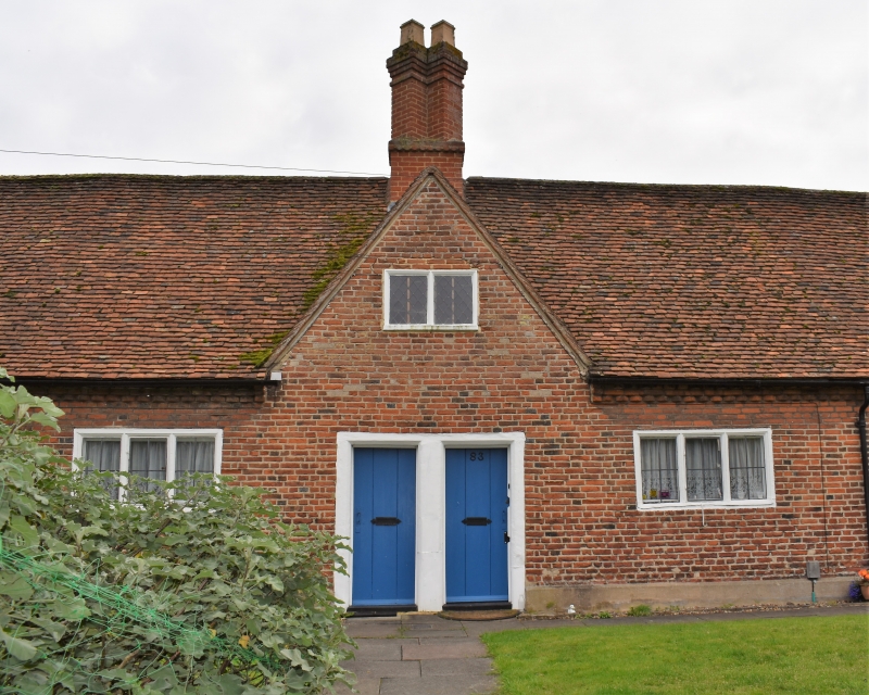
Almshouses. 1653 for Sir Edward Baesh. Red brick in English-
bond with a long steep old red tiled roof. A single storey row
of 3 handed pairs of almshouses facing NW. Each pair has 2
plank doors together, in a heavy chamfered wooden frame, a 3-
light ovolo-moulded casement window with ironcentral opening
light for each house, a gable over the door with a single small
2-light ovolo-moulded window with leaded lattice glazing, and a
shared central chimney with a pair of diagonally set shafts.
Toothed corbel course below the eaves and low plastered plinth.
Modern single-storey small additions at rear and each end. Red
brick wall around elongated forecourt garden, taller at ends,
reduced at front but with heavy sloped brick coping reinstated.
Square gatepiers with stone caps and C20 wrought iron gate. A
landmark at a bend in the road at the S end of the village.
Listing NGR: TL3901511533
External links are from the relevant listing authority and, where applicable, Wikidata. Wikidata IDs may be related buildings as well as this specific building. If you want to add or update a link, you will need to do so by editing the Wikidata entry.


Other nearby listed buildings
