Approximate Location Map
Large Map »
Latitude: 51.4936 / 51°29'36"N
Longitude: -0.1187 / 0°7'7"W
OS Eastings: 530700
OS Northings: 178860
OS Grid: TQ307788
Mapcode National: GBR KL.HR
Mapcode Global: VHGQZ.WQMD
Plus Code: 9C3XFVVJ+CG
Entry Name: Boundary wall of former graveyard forming the perimeter of Old Paradise Gardens, including attached gravestones and chest tombs
Listing Date: 27 March 1981
Last Amended: 3 May 2019
Grade: II
Source: Historic England
Source ID: 1080371
English Heritage Legacy ID: 204394
ID on this website: 101080371
Location: Lambeth High Street Recreation Ground, Lambeth, London, SE11
County: London
District: Lambeth
Electoral Ward/Division: Prince's
Parish: Non Civil Parish
Built-Up Area: Lambeth
Traditional County: Surrey
Lieutenancy Area (Ceremonial County): Greater London
Church of England Parish: North Lambeth
Church of England Diocese: Southwark
Tagged with: Wall
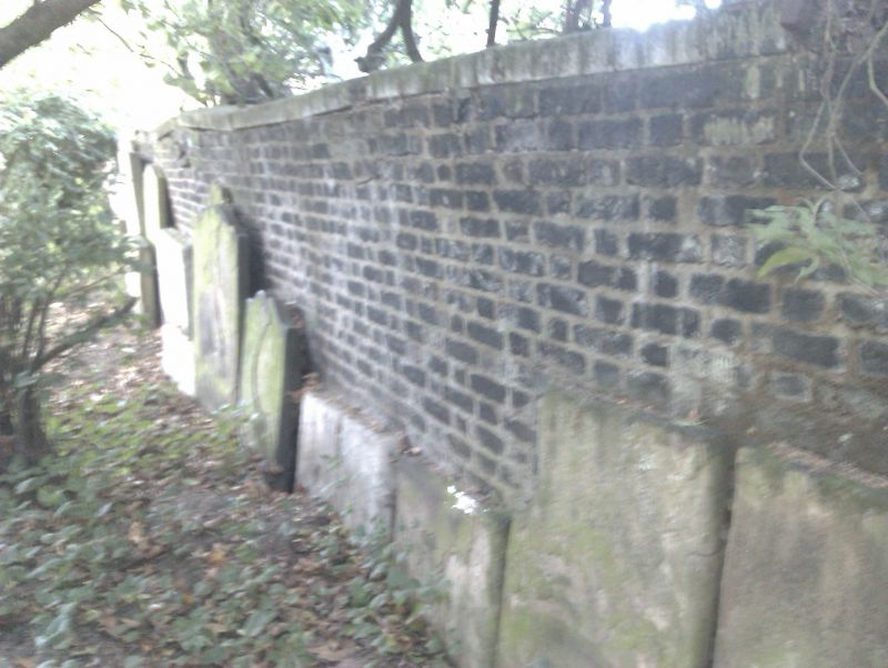
Graveyard boundary wall, probably originally laid out in the C18 but extended and largely rebuilt in about 1815. There are some C20 alterations or additions, which are of lesser interest. Gravestones and chest tombs of C18 and C19 date are attached to the wall.
Graveyard boundary wall, probably originally laid out in the C18 but extended and largely rebuilt in about 1815. There are some C20 alterations or additions, which are of lesser interest. Gravestones and chest tombs of C18 and C19 date are attached to the wall.
MATERIALS: dark red brick laid in Flemish bond with a stone coping in places, and piers and iron railings near the south-east corner.
PLAN: the graveyard boundary wall encloses a broadly L-shaped area.
DESCRIPTION: a graveyard boundary wall with gravestones and chest tombs attached to the interior of the wall, forming the perimeter of an L-shaped former burial ground. Beginning at the north and moving clockwise the wall runs south from Old Paradise Street. The first 4.4m appears to be a later C20 addition and is of lesser interest. It is joined to an early C19 wall, which continues south. This length of wall is 23 courses high above ground level, battered from midsection down and topped by a rowlock course. Gravestones and chest tombs dating to the C18 and C19 are mortared onto the inside edge. The wall meets a pier topped by a coping stone before heading east behind Gabriel House; a length of similar early C19 construction, incorporating a further pier, except for a 13.6m section at the east end which is constructed of C20 glazed brick. This 13.6m length of C20 wall is of lesser interest. At the north-east corner of the former burial ground there is an approximate 10m gap in the original course of the wall but beyond that it survives as lower courses running south. Abutting the lower courses is a separate wall* of C20 rendered brick; this wall is not included in the listing. At a distance of about 38m from the north-east corner, the early C19 boundary wall rises to full height surmounted by a stone coping. It continues running south before it meets a lower wall topped by an iron railing at the south-east corner of the former burial ground where there is an entrance formed of brick piers surmounted by concrete caps. The south length varies in height, still with gravestones mortared onto the inside, reducing to a low level where it meets the west length behind Whitgift House. From the south-west corner, the west length of boundary wall runs northwards, varying in height and incorporating later phases. There is: a relieving arch near the corner, probably for a former opening (now blocked); an entrance flanked by brick piers near the middle of this length; and an external blind arcade of four arches and buttresses near the north end. Adjoining the north end is a 7.3m length of wall of probable later C20 construction, which heads west towards Lambeth High Street and is of lesser interest.
* Pursuant to s1 (5A) of the Planning (Listed Buildings and Conservation Areas) Act 1990 (‘the Act’), it is declared that this aforementioned feature is not of special architectural or historic interest.
The manor of Lambeth belonged to the Archbishop of Canterbury from the late C12. Lambeth Palace, the residence of the Archbishop, was situated opposite the Palace of Westminster and the two were linked by a horse ferry across the Thames. Lambeth was sparsely populated prior to the C18 but subsequently became an important manufacturing centre and a parliamentary borough in 1832. Between 1801 and 1831, the population of Lambeth trembled and in the next 10 years it rose to 105,883 before increasing nearly threefold by 1901.
The site at Old Paradise Gardens is an area of land that is recorded as having been used from about 1703 to 1853 as a burial ground for the parish of Lambeth. According to several sources, it was donated to the parish by Thomas Tenison, Archbishop of Canterbury (1636-1715), and consecrated in about 1705 to meet the growing need for burial space. The burial ground is depicted on Richard Horwood’s map of London of 1792 to 1799, which shows it covering the southern part of the current site. It was extended to the north in about 1815, essentially forming the current footprint, but after becoming full was closed in 1853. Most of the current brick boundary wall appears to date from about 1815, with some possible re-use of earlier fabric, as well as some later phases, alterations and additions. A watch house was erected at the west of the site on Lambeth High Street in 1825 for holding ‘the drunk and disorderly’ and is marked by a commemorative stone. A mortuary is shown at the north-east corner of the site in 1876 but had been rebuilt to also include an inquest room and waiting room by 1891. In 1884 Lambeth Vestry converted the former graveyard into a public garden. Gravestones from the original burial space were moved to the boundary walls. The buildings at the north-east corner of the park were later demolished, probably in the late 1970s when the recreation ground was re-landscaped. The boundary wall was listed at Grade II on 27 March 1981.
The boundary wall of a former graveyard now forming the perimeter of Old Paradise Gardens, probably laid out in the C18 but extended and largely rebuilt in about 1815, is listed at Grade II for the following principal reasons:
Architectural interest:
* for the blind arcading and the C18 and later chest tombs and gravestones attached to the wall.
Historic interest:
* as the graveyard wall to a burial ground used by the parish of Lambeth from about 1703 to 1853 near Lambeth Palace, originally donated by Thomas Tenison, Archbishop of Canterbury (1636-1715), to meet an urgent need for burial space in London.
External links are from the relevant listing authority and, where applicable, Wikidata. Wikidata IDs may be related buildings as well as this specific building. If you want to add or update a link, you will need to do so by editing the Wikidata entry.


Other nearby listed buildings
