Approximate Location Map
Large Map »
Latitude: 51.5052 / 51°30'18"N
Longitude: -0.2083 / 0°12'30"W
OS Eastings: 524445
OS Northings: 179995
OS Grid: TQ244799
Mapcode National: GBR C8.S5Q
Mapcode Global: VHGQY.BFQG
Plus Code: 9C3XGQ4R+3M
Entry Name: Boundary Wall of Number 90
Listing Date: 14 March 1973
Grade: II
Source: Historic England
Source ID: 1080634
English Heritage Legacy ID: 203842
ID on this website: 101080634
Location: Notting Hill, Kensington and Chelsea, London, W11
County: London
District: Kensington and Chelsea
Electoral Ward/Division: Holland
Parish: Non Civil Parish
Built-Up Area: Kensington and Chelsea
Traditional County: Middlesex
Lieutenancy Area (Ceremonial County): Greater London
Church of England Parish: St George, Campden Hill
Church of England Diocese: London
Tagged with: Wall
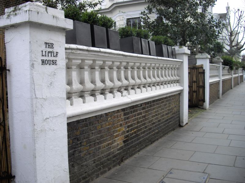
TQ 2479 NW HOLLAND PARK W11
28/1
14.3.73
Boundary Wall of No 90
GV
II
Forecourt wall. Circa 1860-70. Brick plinth with blind stucco balustrade crowned by
capping.
Listing NGR: TQ2444579995
External links are from the relevant listing authority and, where applicable, Wikidata. Wikidata IDs may be related buildings as well as this specific building. If you want to add or update a link, you will need to do so by editing the Wikidata entry.


Other nearby listed buildings
