Approximate Location Map
Large Map »
Latitude: 51.4988 / 51°29'55"N
Longitude: -0.1697 / 0°10'10"W
OS Eastings: 527144
OS Northings: 179348
OS Grid: TQ271793
Mapcode National: GBR 6J.2X
Mapcode Global: VHGQZ.0LMD
Plus Code: 9C3XFRXJ+G4
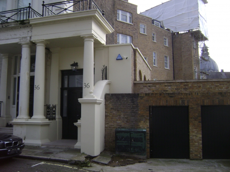
Entry Name: 36, Ennismore Gardens SW7
Listing Date: 15 April 1969
Grade: II
Source: Historic England
Source ID: 1080652
English Heritage Legacy ID: 203781
ID on this website: 101080652
Location: Knightsbridge, Kensington and Chelsea, London, SW7
County: London
District: Kensington and Chelsea
Electoral Ward/Division: Brompton & Hans Town
Parish: Non Civil Parish
Built-Up Area: Kensington and Chelsea
Traditional County: Middlesex
Lieutenancy Area (Ceremonial County): Greater London
Church of England Parish: Holy Trinity South Kensington
Church of England Diocese: London
Tagged with: Building
TQ 2779 SW ENNISMORE GARDENS SW7
40/2
15.4.69 No 36
GV
II
Mid C19. Stuccoed Doric portico leading to covered way which is part of No 31 Brompton
Square QV.
Listing NGR: TQ2714479348
External links are from the relevant listing authority and, where applicable, Wikidata. Wikidata IDs may be related buildings as well as this specific building. If you want to add or update a link, you will need to do so by editing the Wikidata entry.


Other nearby listed buildings
