Approximate Location Map
Large Map »
Latitude: 52.2526 / 52°15'9"N
Longitude: -2.1847 / 2°11'4"W
OS Eastings: 387486
OS Northings: 261623
OS Grid: SO874616
Mapcode National: GBR 1FF.LH5
Mapcode Global: VH92G.2MWZ
Plus Code: 9C4V7R38+34
Entry Name: Churchfields Farmhouse
Listing Date: 14 March 1969
Last Amended: 21 March 1985
Grade: II
Source: Historic England
Source ID: 1081118
English Heritage Legacy ID: 148127
ID on this website: 101081118
Location: Salwarpe, Wychavon, Worcestershire, WR9
County: Worcestershire
District: Wychavon
Civil Parish: Salwarpe
Traditional County: Worcestershire
Lieutenancy Area (Ceremonial County): Worcestershire
Church of England Parish: Salwarpe and Hindlip with Martin Hussingtree
Church of England Diocese: Worcester
Tagged with: Farmhouse
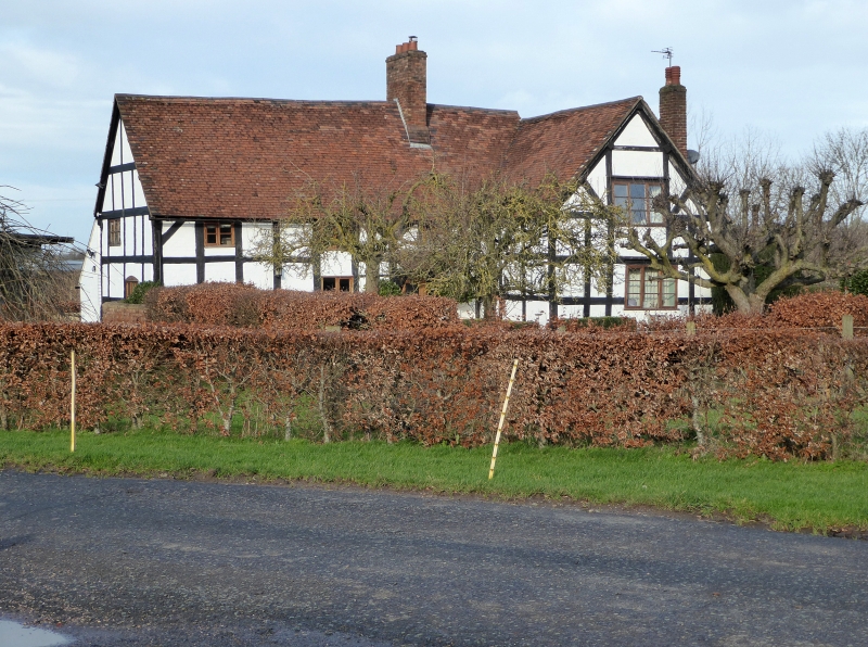
SO 86 SE SALWARPE CP SALWARPE
4/231 Churchfields Farmhouse
14.3.69
- II
Farmhouse. Early Cl7 with mid-C19 and mid-C20 alterations and additions.
Timber-framed, painted brick infill, brick replacement walling and refacing,
plain tiled roofs, rebuilt brick stack to main ridge and also external
chimney to right side (north) elevation with tiled offsets. Hall and
cross-wing type plan, cross-wing at north-east gable end, main range of
three framed bays, large chimney in north-east end bay and lobby-entry
plan, with cross-wing of two framed bays; two storeys. Framing: three
square panels from sill to wall-plate, short straight braces in upper
corners, collar-and-tie-beam trusses now mostly rebuilt in brick.
Front elevation: main range has one ground and three first floor 2-light
casements; lean-to tiled porch on brackets and C20 half-glazed door; cross-
wing gable end has two 3-light casements with cambered heads. Interior:
roof has intermediate collar-and-tie-beam trusses, single row of trenched
purlins and straight wind-braces; cambered doorhead on first floor of main
part; back-to-back inglenook fireplaces with bread oven. Outshut to rear
main part and C20 single storey extension to rear cross-wing. Birmingham
fire insurance mark on tie-beam at south-west gable end.
Listing NGR: SO8748661623
External links are from the relevant listing authority and, where applicable, Wikidata. Wikidata IDs may be related buildings as well as this specific building. If you want to add or update a link, you will need to do so by editing the Wikidata entry.


Other nearby listed buildings
