Approximate Location Map
Large Map »
Latitude: 52.0383 / 52°2'18"N
Longitude: -2.0755 / 2°4'31"W
OS Eastings: 394917
OS Northings: 237774
OS Grid: SO949377
Mapcode National: GBR 2KL.435
Mapcode Global: VH93N.Z147
Plus Code: 9C4V2WQF+8Q
Entry Name: The Hermitage
Listing Date: 21 April 1980
Grade: II
Source: Historic England
Source ID: 1081613
English Heritage Legacy ID: 148542
ID on this website: 101081613
Location: Kemerton, Wychavon, Worcestershire, GL20
County: Worcestershire
District: Wychavon
Civil Parish: Kemerton
Built-Up Area: Kemerton
Traditional County: Gloucestershire
Lieutenancy Area (Ceremonial County): Worcestershire
Church of England Parish: Kemerton St Nicholas
Church of England Diocese: Gloucester
Tagged with: Building Thatched cottage
KEMERTON CP UPPER KEMERTON
SO 9437 - 9537
9/89 21/122 The Hermitage
21-4-80
- II
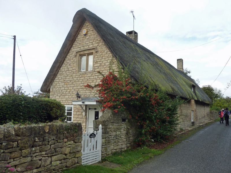
Shown on OS Map as The Cottage/The Hermitage.
Row of three or four houses, now one dwelling. Probably late C17, extended
c1800 with late C20 alterations. Coursed limestone rubble and thatched roof,
half-hipped at west end, with a brick ridge stack and a C20 rubble stack to
south of ridge. Five bays aligned east/west (the two east bays and the west
end bay are c1800 additions). Single storey and attic with dormers. South
front elevation: windows are mainly C20 casements. There are two 2-light
windows, two rectangular lights and a 3-light C19 casement on the ground floor
and five eyebrow dormers, two with 2-light windows, two with 3-light windows
and one with a C19 single-light window. One ground floor window has been
replaced with a pair of C20 glazed doors. The main entrance is presently at
the east gable end and has a flat canopy on brackets and a C20 stable door.
The attic window above the entrance is a 2-light chamfered mullioned window
and has a hoodmould with returns. The north elevation facing the road has
a central 2-light casement with an eyebrow dormer and 2-light casement above.
Interior: there is said to be some internal timber-framing.
Listing NGR: SO9491737774
External links are from the relevant listing authority and, where applicable, Wikidata. Wikidata IDs may be related buildings as well as this specific building. If you want to add or update a link, you will need to do so by editing the Wikidata entry.


Other nearby listed buildings
