Approximate Location Map
Large Map »
Latitude: 54.0709 / 54°4'15"N
Longitude: -0.573 / 0°34'22"W
OS Eastings: 493477
OS Northings: 464823
OS Grid: SE934648
Mapcode National: GBR SPFC.RG
Mapcode Global: WHGCX.5YD2
Plus Code: 9C6X3CCG+8R
Entry Name: The Well and Railings
Listing Date: 20 September 1966
Grade: II
Source: Historic England
Source ID: 1083769
English Heritage Legacy ID: 167872
ID on this website: 101083769
Location: Sledmere, East Riding of Yorkshire, YO25
County: East Riding of Yorkshire
Civil Parish: Sledmere
Traditional County: Yorkshire
Lieutenancy Area (Ceremonial County): East Riding of Yorkshire
Church of England Parish: Sledmere St Mary
Church of England Diocese: York
Tagged with: Building
SLEDMERE MAIN STREET
SE 9264-9364 (north side)
17/62 The Well and railings
20.9.66
GV II
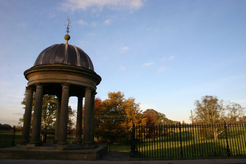
Monument and railings. 1840. Built for Sir Tatton Sykes, 4th Baronet, in
memory of his father Sir Christopher Sykes, 2nd Baronet. Sandstone ashlar
with lead roof, and iron railings. Monument in the form of a circular
temple. Square plinth, octagonal base, 8 Greek Doric
columns supporting frieze and cornice with domed roof surmounted by ball
finial and weather-vane with fox. Central area with glazed cover.
Inscription to frieze reads: 'THIS EDIFICE WAS ERECTED BY SIR TATTON SYKES
BART. TO THE MEMORY OF HIS FATHER SIR CHRISTOPHER SYKES BART, / WHO BY
ASSIDUITY AND PERSEVERANCE IN BUILDING AND PLANTING AND INCLOSING ON THE
YORKSHIRE WOLDS, IN THE SHORT / SPACE OF THIRTY YEARS, SET SUCH AN EXAMPLE
TO OTHER OWNERS OF LAND, AS HAS CAUSED WHAT ONCE WAS A BLEAK AND BARREN /
TRACT OF COUNTRY TO BECOME NOW ONE OF THE MOST PRODUCTIVE AND BEST
CULTIVATED DISTRICTS IN THE COUNTY OF YORK. AD. 1840'. Railings to sides
and rear: lances with ornamental standards between each 17 rails. Upper row
of bars. Approximately 16 metres to either side and around the rear.
Listing NGR: SE9347764823
External links are from the relevant listing authority and, where applicable, Wikidata. Wikidata IDs may be related buildings as well as this specific building. If you want to add or update a link, you will need to do so by editing the Wikidata entry.


Other nearby listed buildings
