Approximate Location Map
Large Map »
Latitude: 51.0964 / 51°5'46"N
Longitude: 0.5378 / 0°32'15"E
OS Eastings: 577793
OS Northings: 136070
OS Grid: TQ777360
Mapcode National: GBR PTC.4S3
Mapcode Global: FRA D607.3BP
Plus Code: 9F323GWQ+G4
Entry Name: Cranbrook School House and Walls to South
Listing Date: 9 June 1952
Grade: II*
Source: Historic England
Source ID: 1084796
English Heritage Legacy ID: 169153
ID on this website: 101084796
Location: Cranbrook, Tunbridge Wells, Kent, TN17
County: Kent
District: Tunbridge Wells
Civil Parish: Cranbrook & Sissinghurst
Built-Up Area: Cranbrook
Traditional County: Kent
Lieutenancy Area (Ceremonial County): Kent
Tagged with: Architectural structure
CRANBROOK WATERLOO ROAD
TQ 7736 SE
(north west side)
10/302
9.6.52 Cranbrook School House
and walls to south
GV II*
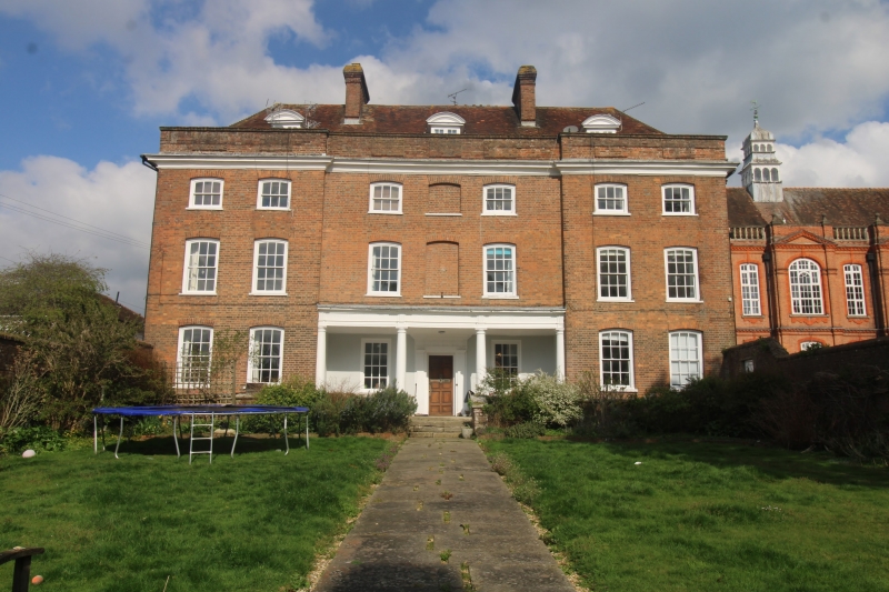
School house to Cranbrook School, now Headmaster's House. 1727. Red brick
on red brick plinth. Coved wooden cornice to parapet with raised panel.
Plain tiled hipped roof with 2 stacks across the ridge and 3 dormers with
segmental pediments. 3 storeys and attic. 7 bays with slight 2 bay end
projections. Ganged segment heads to glazing bar sashes, those on second
floor half the depth of those below. Blocked windows on first and second
floor in centre. Deep ground floor loggia in central 3 bays with wall above
resting on entablature supported by 2 Doric columns with flanking Doric
columns at outer corners of loggia. Triglyphs over columns in frieze. Door-
ways at ends of loggia and in centre, flanked by flat-headed glazing bar
sashes. Central doorway with fluted Doric pilaster surround and triglyphed
entablature. Invicta Fire Insurance plaque in central first floor window.
Blue and red brick chequer wing to rear at left with C19 additions in centre
of rear; wing at right C19 but with C19 roof structure. Red brick walls
30 yards long to front of school house, with two ramped steps down on each
side. Garden closed by low walls, 4 feet high, topped by diagonal railings,
each with flanking piers, 2 intertwining piers and central gate-piers. Wooden
gate with slats above to resemble railings. Interior: stair on 4 levels,
rectangular open well. Twined balusters. Flat hand rail, square newelposts.
Corniced tread-ends and curved cheek-pieces.
Listing NGR: TQ7779336070
External links are from the relevant listing authority and, where applicable, Wikidata. Wikidata IDs may be related buildings as well as this specific building. If you want to add or update a link, you will need to do so by editing the Wikidata entry.


Other nearby listed buildings
