Approximate Location Map
Large Map »
Latitude: 51.2733 / 51°16'23"N
Longitude: 0.5301 / 0°31'48"E
OS Eastings: 576580
OS Northings: 155726
OS Grid: TQ765557
Mapcode National: GBR PR7.2TT
Mapcode Global: VHJMF.48L6
Plus Code: 9F327GFJ+82
Entry Name: 9, Ashford Road
Listing Date: 17 August 1973
Grade: II
Source: Historic England
Source ID: 1086383
English Heritage Legacy ID: 173230
ID on this website: 101086383
Location: Maidstone, Kent, ME14
County: Kent
District: Maidstone
Electoral Ward/Division: High Street
Parish: Non Civil Parish
Built-Up Area: Maidstone
Traditional County: Kent
Lieutenancy Area (Ceremonial County): Kent
Tagged with: Building
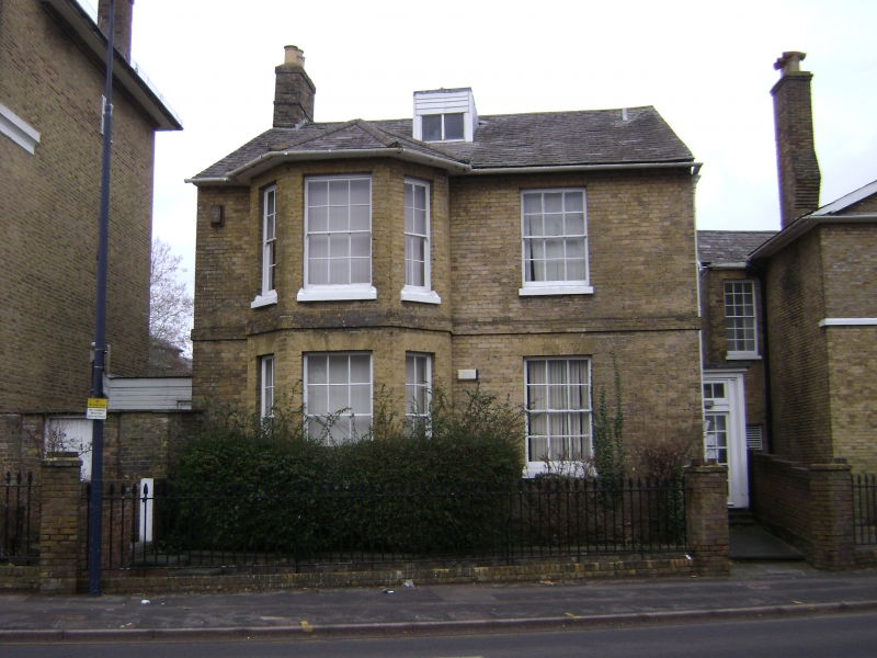
ASHFORD ROAD
1.
5278
(North Side)
No 9
TQ 7655 NE 3/196 17.8.73.
II GV
2.
Early to mid C19. 2 storeys brown brick. Slate roof with 1 dormer having
a casement window. 2 windows, one of which is a 3 light canted bay through
all floors. Glazing bars intact. Doorcase in side elevation.
Nos 7 to 15 (odd) form a group.
Listing NGR: TQ7658055726
External links are from the relevant listing authority and, where applicable, Wikidata. Wikidata IDs may be related buildings as well as this specific building. If you want to add or update a link, you will need to do so by editing the Wikidata entry.


Other nearby listed buildings
