Approximate Location Map
Large Map »
Latitude: 54.3531 / 54°21'11"N
Longitude: -3.0595 / 3°3'34"W
OS Eastings: 331234
OS Northings: 495798
OS Grid: SD312957
Mapcode National: GBR 7L23.F9
Mapcode Global: WH71D.ZV77
Plus Code: 9C6R9W3R+65
Entry Name: Lodge and former stable approximately 70 metres to south of Brantwood
Listing Date: 22 September 1987
Grade: II*
Source: Historic England
Source ID: 1087283
English Heritage Legacy ID: 76776
ID on this website: 101087283
Location: Westmorland and Furness, Cumbria, LA21
County: Cumbria
District: South Lakeland
Civil Parish: Coniston
Traditional County: Lancashire
Lieutenancy Area (Ceremonial County): Cumbria
Church of England Parish: Coniston and Torver
Church of England Diocese: Carlisle
This list entry was subject to a Minor Amendment on 14 April 2022 to remove superfluous amendment details and to reformat the text to current standards
SD 39 NW
5/70
CONISTON
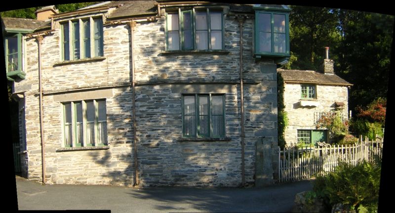
Lodge and former stable approx 70m to south of Brantwood
GV
II*
Lodge and stable. Stable probably C18; lodge 1872 for John Ruskin. Roughcast stone with slate roof, rear wing stone rubble. Two storeys, two bays, with smaller, recessed two-bay wing to rear. Left angle is canted. Slate dripcourse over ground floor. Ground floor has four- and three-light mullioned windows, with two-light window to angle. First floor has four-light flat-topped dormer; to canted angle a canted oriel dormer with gable and small return lights. Right hand angle has gabled oriel dormer set across angle with pyramidal roof. Left return has sashed windows, first floor loading door and lateral stack. Right return has lateral stack and entrance; rear wing has two entrances each with small-paned light to left. First floor windows. Opening to rear wall to take waterfall, stream partly culverted through building emerging through opening in front wall.
Listing NGR: SD3123495798
External links are from the relevant listing authority and, where applicable, Wikidata. Wikidata IDs may be related buildings as well as this specific building. If you want to add or update a link, you will need to do so by editing the Wikidata entry.


Other nearby listed buildings
