Approximate Location Map
Large Map »
Latitude: 51.7636 / 51°45'49"N
Longitude: -2.3357 / 2°20'8"W
OS Eastings: 376927
OS Northings: 207270
OS Grid: SO769072
Mapcode National: GBR 0KW.B9V
Mapcode Global: VH94P.GXKW
Plus Code: 9C3VQM77+FP
Entry Name: Fromebridge Mill
Listing Date: 9 December 1986
Grade: II
Source: Historic England
Source ID: 1090532
English Heritage Legacy ID: 132372
ID on this website: 101090532
Location: Fromebridge, Stroud, Gloucestershire, GL2
County: Gloucestershire
District: Stroud
Civil Parish: Whitminster
Traditional County: Gloucestershire
Lieutenancy Area (Ceremonial County): Gloucestershire
Church of England Parish: Frampton-on-Severn St Mary
Church of England Diocese: Gloucester
Tagged with: Mill
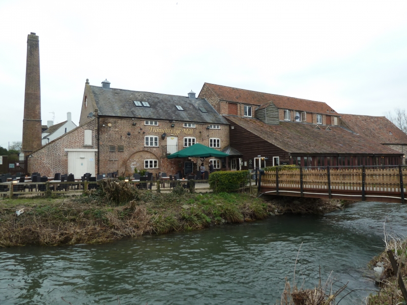
FRAMPTON-ON-SEVERN FROMEBRIDGE
SO 70 NE
6/114 Fromebridge Mill
GV II
Mill. Site of mill since Domesday, variably a corn, fulling, wire
and brass mill, now in use for animal feeds; rebuilt in late C18
and extended probably mid C19. Brick, with some slag block
walling in oldest section with slate roof, corrugated asbestos roof
to later wing to north. Main block of 2 storeys and loft, with
coped verges, kneelers and finial to south gable end above large
lean-to with pantile roof and large tapering brick chimney tower to
left corner, rounded right hand corner. Keyed oculus on gable
end. Slag blocks on west side only towards mill leat, with small
scattered fenestration. East side has cambered head 3-light
window openings flanking door on first floor up flight of 7 stone
steps. In this section machinery intact and still in use powered
by water driven turbine on side of mill leat closest to building.
One large undershot water wheel still exists on other side of mill
leat but not in use. Large brick rear building of 3 floors with
10 windows to west, mostly bricked up, with cambered heads to lower
2 floors, and large C20 lean-to to east. Internal construction of
timber posts and beams.
(V.C.H., Gloucestershire, Vol X, 1972)
Listing NGR: SO7692707270
External links are from the relevant listing authority and, where applicable, Wikidata. Wikidata IDs may be related buildings as well as this specific building. If you want to add or update a link, you will need to do so by editing the Wikidata entry.


Other nearby listed buildings
