Approximate Location Map
Large Map »
Latitude: 51.7936 / 51°47'37"N
Longitude: -2.4269 / 2°25'36"W
OS Eastings: 370653
OS Northings: 210641
OS Grid: SO706106
Mapcode National: GBR FZ.Y0MQ
Mapcode Global: VH875.W5CT
Plus Code: 9C3VQHVF+F6
Entry Name: Raisher and Unidentified Monument, About 17M South-South-East of Tower in Churchyard of Church of St Mary
Listing Date: 9 December 1986
Grade: II
Source: Historic England
Source ID: 1090578
English Heritage Legacy ID: 132275
ID on this website: 101090578
Location: St Mary's Church, Arlingham, Stroud, Gloucestershire, GL2
County: Gloucestershire
District: Stroud
Civil Parish: Arlingham
Built-Up Area: Arlingham
Traditional County: Gloucestershire
Lieutenancy Area (Ceremonial County): Gloucestershire
Church of England Parish: Arlingham St Mary the Virgin
Church of England Diocese: Gloucester
Tagged with: Monument
ARLINGHAM CHURCH ROAD
SO 71 SW
(west side)
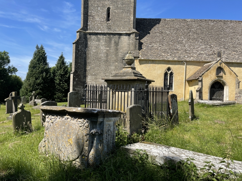
2/17 Raisher and Unidentified Monument,
about 17m south-south-east of
tower in churchyard of Church of
St. Mary
GV II
Chest and railed pedestal tomb. From north to south: pedestal
tomb to Raisher family, 1798 earliest; unidentified chest tomb,
probably mid C18. Raisher - Forest limestone, stepped cap with
urn-like finial on flat top, tall plain plinth, on base with tall
spearhead railings and corner urns. Square with unfluted corner
columns, pointed arch panels with colonnette jambs and cherubs'
heads in spandrels to each side, but all different. Unidentified -
limestone, flat top, moulded plinth and capping. Gadrooned quarter
balusters, recessed end panels with urn to west and torch to east,
relief cartouche to north side and raised oval to south with carved
surround.
Listing NGR: SO7065310641
External links are from the relevant listing authority and, where applicable, Wikidata. Wikidata IDs may be related buildings as well as this specific building. If you want to add or update a link, you will need to do so by editing the Wikidata entry.


Other nearby listed buildings
