Approximate Location Map
Large Map »
Latitude: 51.38 / 51°22'48"N
Longitude: 0.3606 / 0°21'38"E
OS Eastings: 564377
OS Northings: 167196
OS Grid: TQ643671
Mapcode National: GBR NNB.G05
Mapcode Global: VHJLR.6KHY
Plus Code: 9F3299J6+26
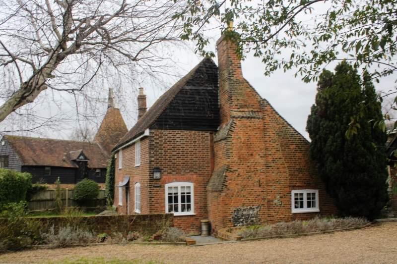
Entry Name: Evenden Farmhouse
Listing Date: 8 November 1976
Grade: II
Source: Historic England
Source ID: 1096354
English Heritage Legacy ID: 356825
ID on this website: 101096354
Location: Hook Green, Gravesham, Kent, DA13
County: Kent
District: Gravesham
Civil Parish: Meopham
Built-Up Area: Meopham
Traditional County: Kent
Lieutenancy Area (Ceremonial County): Kent
Church of England Parish: Meopham St John the Baptist
Church of England Diocese: Rochester
Tagged with: Farmhouse
TQ 66 NW MEOPHAM WROTHAM ROAD
4/96 (west side)
8.11.76 Evenden Farmhouse
II
C17 timber-framed, cased in red brick with grey headers. C19 east gable which has
large brick chimney stack partly weatherboarded. Gabled tiled roof.
Listing NGR: TQ6437767196
External links are from the relevant listing authority and, where applicable, Wikidata. Wikidata IDs may be related buildings as well as this specific building. If you want to add or update a link, you will need to do so by editing the Wikidata entry.


Other nearby listed buildings
