Approximate Location Map
Large Map »
Latitude: 52.2569 / 52°15'24"N
Longitude: -2.1862 / 2°11'10"W
OS Eastings: 387383
OS Northings: 262093
OS Grid: SO873620
Mapcode National: GBR 1FF.D3T
Mapcode Global: VH92G.2J2R
Plus Code: 9C4V7R47+PG
Entry Name: The Mill House
Listing Date: 14 March 1969
Last Amended: 21 March 1985
Grade: II
Source: Historic England
Source ID: 1096360
English Heritage Legacy ID: 148130
ID on this website: 101096360
Location: Salwarpe, Wychavon, Worcestershire, WR9
County: Worcestershire
District: Wychavon
Civil Parish: Salwarpe
Traditional County: Worcestershire
Lieutenancy Area (Ceremonial County): Worcestershire
Church of England Parish: Salwarpe and Hindlip with Martin Hussingtree
Church of England Diocese: Worcester
Tagged with: House
SO 86 SE SALWARPE CP SALWARPE
4/234 The Mill House
(formerly listed as
Corn Hill House)
14.3.69
- II
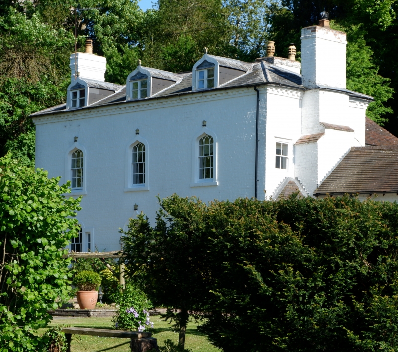
Shown on OS Map as Mill Cottage.
Miller's house, now house. c1785 with mid-C19 and mid-C20 alterations and
additions. Painted brick, low-pitched hipped slate roof, external brick
stacks at ends with tiled offsets. Two storeys and attic with dormers;
dentilled eaves cornice; three bays; front elevation has Gothick detailing;
windows are ogee-headed glazing bar sashes and have ogee-arched architraves
with moulded finials; ground floor windows have side lights in the manner
of Venetian windows; three gabled dormers with slate-hung cheeks and C20
ogee-arched bargeboards and 2-light casements; central round-arched entrance
has moulded ogee-arched architrave and finial, a 6-panelled door and side
reveals with raised and fielded panels and a traceried, segmental fanlight.
Interior not inspected. There is a two-storey wing to the rear left.
Salwarpe Mill stood to the front right of the house and was demolished in
1942.
Listing NGR: SO8738362093
External links are from the relevant listing authority and, where applicable, Wikidata. Wikidata IDs may be related buildings as well as this specific building. If you want to add or update a link, you will need to do so by editing the Wikidata entry.


Other nearby listed buildings
