Approximate Location Map
Large Map »
Latitude: 52.8214 / 52°49'17"N
Longitude: -1.5361 / 1°32'9"W
OS Eastings: 431360
OS Northings: 324976
OS Grid: SK313249
Mapcode National: GBR 6G4.2GV
Mapcode Global: WHCG7.CBSW
Plus Code: 9C4WRFC7+HH
Entry Name: Ruin of Stable in Repton Park
Listing Date: 19 January 1967
Last Amended: 10 August 2012
Grade: II
Source: Historic England
Source ID: 1096509
English Heritage Legacy ID: 82767
ID on this website: 101096509
Location: South Derbyshire, DE65
County: Derbyshire
District: South Derbyshire
Civil Parish: Repton
Traditional County: Derbyshire
Lieutenancy Area (Ceremonial County): Derbyshire
Church of England Parish: Repton St Wystan
Church of England Diocese: Derby
Tagged with: Building
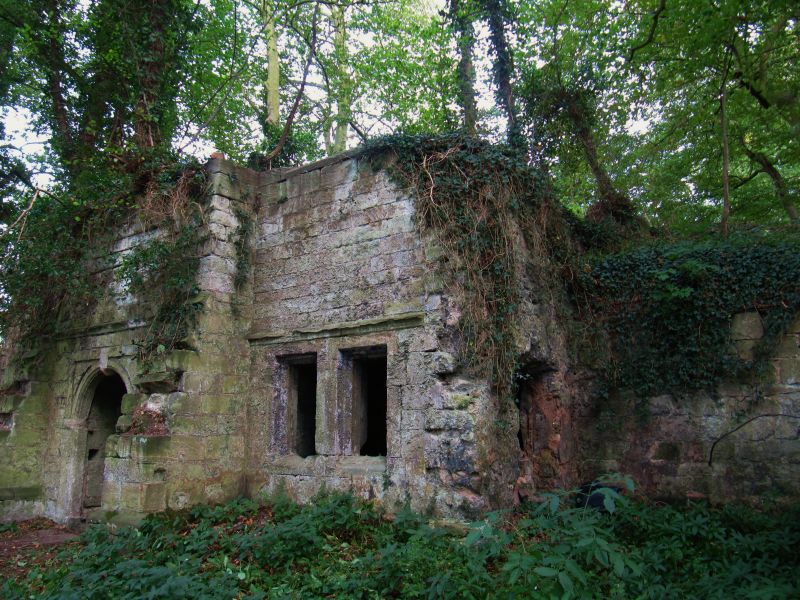
Ruin of small, early-C17 stable.
PLAN: the stable has a rectangular plan with side wings which are possibly the remains of coach houses.
MATERIALS: coursed squared sandstone with sandstone dressings, and red brick. The outer walls bear traces of brown cement render which was probably applied in the early C19.
EXTERIOR: the stable is built into the hillside and its roof is overgrown. The west elevation of the single-storey building has three bays with a central moulded and keyed round-arched doorway with squared surround, panelled spandrels, and moulded horizontal hoodmould. This is flanked by substantial buttresses with the remains of off-sets. The outer bays have two single-light windows, closely spaced, with recessed and cavetto moulded surrounds, and a horizontal hoodmould. The thick walls and buttresses anticipate the danger of a forward thrust of earth from the hillside. The slope in front of the building has been modified to create a platform for the drive.
INTERIOR: this is a single space with a depressed, stone, barrel-vault roof. The end walls are lined in brick and the rear wall has the remains of a brick lining with a narrow banding.
The origins of Repton Park date to the early C17 when the Harpur family of Swarkestone, later of Calke, built a lodge and stable in the newly-purchased woodlands there. The earliest known map of the park, produced in 1762, shows a natural landscape, the only designed element being the large pond in the north-west corner, with a wide band of trees along the east side of the water, following the route of the stream. The stable is depicted in the northern part of this woodland and is shown to have a rectangular plan. The lodge was later refashioned in 1810-12 in a Gothick style for Sir Henry Crewe of Calke by the architect Samuel Brown of Derby, and was altered again between 1821 and 1827 to become a small country house. A map produced in 1829 shows that work was also carried out in the park, possibly under the direction of Samuel Brown. The map shows that the woodland was cut back, as the stable, with its clearly delineated side wings, is now shown on its northern tip. Subsequent work to the parkland included the planting of a lime avenue running north-south from the park entrance on Red Lane to the stable, clearly marked on the 1887 Ordnance Survey map. The house was demolished in 1896, as a result of a family dispute, and only its foundations remain. The park itself has not been maintained since the late C19, consequently becoming overgrown with brambles and trees.
It has been suggested that this building was originally used as a deer larder and was later adapted as a stable but there is no evidence for this. However, the building has been altered over the years. The map evidence suggests that the side wings could have been added between 1762 and 1829. It has been suggested that the horizontal groove on the northern wing indicates the former position of a roof, suggesting that the wings were coach houses. A stone base with a metal pintle is all that remains of a gate pier which would have formed the gateway to the northern one. The right-hand wall of the stable has been lined in red brick, probably in the mid-C19, and there are remains of a red-brick lining with a narrow banding along the rear wall. The interior right hand wall has the ghosting of a stall. It is claimed that there was an upper floor but the overgrown nature of the site precludes any definitive interpretation. The building has been ruinous for a long time.
The ruin of an early-C17 stable at Repton Park is designated at Grade II for the following principal reasons:
* Architectural interest: it is a well-crafted building with architectural detailing of a high quality; notably the moulded dressings and the impressive stone barrel-vaulted roof;
* Historic interest: it is a building of status that was positioned along the route to the lodge in order to display the taste and wealth of the owner. Whilst it has lost its architectural context through the demolition of the C17 lodge and the early-C19 house that replaced it, elements of the designed landscape still survive to place the stable in its historic context;
* Group value: it has group value with the Grade II listed early-C19 weir and sluice in Repton Park.
External links are from the relevant listing authority and, where applicable, Wikidata. Wikidata IDs may be related buildings as well as this specific building. If you want to add or update a link, you will need to do so by editing the Wikidata entry.


Other nearby listed buildings
